Tricky swell tomorrow, with a downgrade for the weekend
Victorian Surf Forecast by Craig Brokensha (issued Wednesday 5th July)
Best Days: Selected spots tomorrow, later Saturday and Sunday Surf Coast, Monday and Tuesday morning Surf Coast, Wednesday
Features of the Forecast (tl;dr)
- Moderate sized acute W'ly groundswell for tomorrow with strong N/NE tending N winds
- Easing swell Fri with strong NW tending N/NW winds later
- Building mid-period W'ly swell Sat PM with strong NW tending W/NW winds
- Moderate sized + mid-period W/SW swell peaking Sun AM, easing later and further Mon
- Fresh W/NW winds Sun, NW tending W/NW Mon
- Moderate sized mid-period W/SW swell for Tue with W/NW tending S/SW winds
Recap
Our tricky SW groundswell expected from an off-axis fetch of gale to severe-gale NW winds to the south-west of Western Australia came in nicely yesterday. It was expected to peak Monday evening but instead peaked yesterday morning with good 3ft sets across the Surf Coast and 4-5ft waves to the east. The swell slowed a little into the afternoon with this morning seeing smaller, easing 1-2ft waves on the Surf Coast and 3ft sets to the east.

Fun surf yesterday AM
This week and weekend (Jul 6 - 9)
One tricky swell down, one more to go.

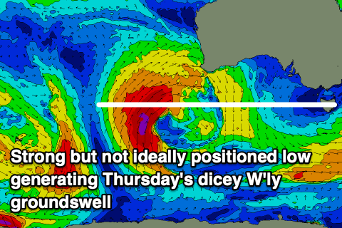
Following yesterday's tricky SW groundswell, we've got a less reliable and acute W'ly groundswell due to peak through tomorrow, generated by a severe low off the Western Australian coast earlier in the week.
This low sat north in our swell window and wasn't ideally aligned, but the strength was significant. The low produced stormy XXL swell to Western Australia and we should see some decent radial spread out from a fetch of gale to severe-gale winds just within our swell window.
The Surf Coast will be very inconsistent thanks to the westerly angle of the swell but magnets should hopefully see 2-3ft sets, while to the east expect mostly 4-5ft waves with the possible rare bigger one in the mix.
Strong N/NE winds will favour selected spots through the morning, possibly shifting N'ly through the afternoon.
This swell will ease through Friday from an inconsistent 2ft or so on the Surf Coast magnets with easing 4ft sets to the east. Strong NW winds will shift more N/NW through the day on Friday so less than ideal.
A low point in swell is expected Saturday morning ahead of some building mid-period W'ly swell through the day ahead of our larger swell due Sunday.

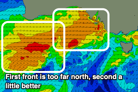
There's just one small issue with this coming progression compared to Monday's forecast and that's that the incoming mid-latitude frontal activity has been shifted a little north which isn't ideal at all.
We'll see back to back frontal systems pushing up close and under Western Australia, then through the Bight. The first system now looks to be a little too far north in latitude while the secondary system will only just be a little better with a more localised fetch of W-W/SW gales developing directly west of us, under South Australia on Saturday.
All in all this now looks dicey with the swell now mostly due to be localised, mid-period energy and west in nature.
So set your expectations low. During Saturday we're likely to see building surf to 3ft+ on the Surf Coast through the late afternoon, 6ft to the east along with strong NW tending W/NW winds.

Sunday looks to be in the 4-5ft range across the exposed breaks on the Surf Coast, 6-8ft to the east. Winds should be strong out of the W/NW for most of the day Sunday, possibly more W'ly at dawn but improving ahead of the next frontal system.
Monday looks smaller and weaker ahead of the next mid-period swell that's due to arrive through Tuesday.
A good fetch of pre-frontal W/NW winds are expected to give way to a low, pushing in quickly under the Bight Monday. Stronger gale-force W/SW winds are forecast with a moderate sized pulse of swell due Tuesday to 4ft on the Surf Coast and 6ft+ to the east.
NW tending W/NW winds should create clean conditions Monday, while Tuesday looks clean in the morning with a W/NW breeze before the tail of the front brings a shallow S/SW change for the afternoon. Wednesday looks fun with easing surf as winds tend more N/NW, possibly shifting N/NE into the afternoon to the east but we'll have a closer look at this Friday.
Longer term, the next increase in swell looks to be later week but we'll have a closer look at this and confirm Sunday's sizes on Friday.


Comments
Buttery conditions and super fun swell yesterday morning on the surf coast, it seemed to turn on for about an hour before the high tide. Not many about where I was so waves were being shared & happy vibes
Gold!
:)
Localised winds for porto - gunna will see fresh winds West of North tending NNW
It was bombing 2ft sets
Epic !!!!!
Nothing like a Bomb 2 foot set……
Models are over cooking next weeks swell?
It's all still quite fluid.
Gotcha
bloody tricked me here Craigos - got all worked up with the boyz for a big weekend of pipes.
Looks like off to Crown with the lovely. Yewww
You’ll be having plenty of pipes at crown no doubt shetrickedme3!