Weaker swells but fun surf
Victorian Surf Forecast by Craig Brokensha (issued Monday 26th June)
Best Days: Today Surf Coast, Thursday Surf Coast, Friday Surf Coast, likely Sunday morning Surf Coast
Features of the Forecast (tl;dr)
- Moderate sized spike in localised W/SW swell today, easing rapidly into tomorrow with gusty NW winds
- Building moderate sized mid-period SW swell Wed PM, peaking Thu
- Strong W/NW-NW winds shifting S/SW late AM Wed and strengthening into the PM
- Strong W/NW winds Thu, W/NW-W Fri
- Moderate sized SW swell Fri, easing slowly Sat and Sun
- Dawn W/NW shifting quickly strong SW winds Sat, S/SW-SW Sun (likely W/NW in the AM Surf Coast)
Recap
Friday's small, inconsistent swell eased through Saturday but the magnets on the Surf Coast offered infrequent 1-2ft sets for the keen with a touch more size to the west.
Yesterday, an inconsistent W/SW groundswell filled in, a little slow early before reaching 2-3ft through the day on the Surf Coast and 4-5ft to the east but with strong N-N/NW winds, favouring selected breaks.
Today some reinforcing mid-period W/SW swell is offering building surf from 3ft sets on the Surf Coast magnets with favourable winds for protected spots (discussed in more detail below).
This week and weekend (Jun 27 – Jul 2)
The backside of a strong but high-riding mid-latitude low is moving through Bass Strait today and it's producing winds that are a little stronger than forecast last Friday.
With this, a moderate sized mid-period W/SW swell is providing 3-4ft sets on the Surf Coast magnets, with it peaking now through early afternoon.
It'll be a quick spike to make the most of it before it eases through tomorrow. Winds will shift more W-W/SW through the afternoon today and then back W/NW later.
Tomorrow looks clean with gusty NW winds and the swell will be easing back from a weak 2ft on the Surf Coast with 3-4ft sets to the east.
We may see a temporary low point in swell Wednesday morning, but it will be short-lived, with our building mid-period SW swell episode due to arrive through the morning, with further increases in size due through the end of the week, persisting on the weekend.
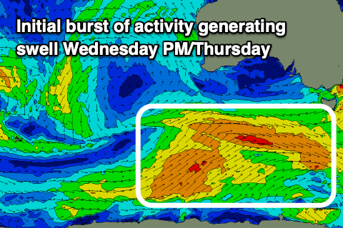
The Southern Ocean frontal progression linked to this activity will be persistent but weak with back to back fetches of strong winds moving through our swell window. Initially a pre-frontal fetch of strong W/NW winds will be followed by post-frontal W/SW winds today and this evening, generating our initial pulse of size Wednesday afternoon and Thursday morning.
The Surf Coast should build to 3ft through Wednesday afternoon with 4-5ft sets to the east, a touch bigger Thursday and to 3ft+ and 4-6ft respectively.

Winds on Wednesday will unfortunately take a turn for the worse as a trough clips us, with morning W/NW-NW winds due to shift S/SW later morning, strengthening into the afternoon as the swell builds.
Thursday looks better ahead of the next approaching frontal system, with strengthening W/NW winds expected, holding most of Friday if not swinging W'ly into the afternoon.
This next flurry of frontal activity should bring a renewal of building mid-period swell through Friday, pushing to 4ft on the Surf Coast and 5-6ft to the east, easing a touch Saturday, further Sunday.
While a fun size, the swell looks generally weak in nature so keep this in mind.
Winds on Saturday look dicey with a dawn W/NW'ly due to shift strong SW by mid-morning in the wake of the swell generating fronts, with weaker S/SW-SW winds persisting Sunday. There's a good chance for a light W/NW breeze on the Surf Coast Sunday morning but we'll review this Wednesday.
Longer term the swell looks to continue easing in size into early next week ahead of some new W/SW swell energy building mid-late week with the next passage of frontal activity.

