Good swell for tomorrow with great winds
Victorian Surf Forecast by Craig Brokensha (issued Monday 19th June)
Best Days: Today Surf Coast, tomorrow Surf Coast, beaches Wednesday
Features of the Forecast (tl;dr)
- Moderate sized + mid-period SW tending S/SW swell for later today, easing through tomorrow afternoon
- Mod-fresh but easing W/NW winds tomorrow
- Easing small surf Wed with local offshore tending N/NE winds
- Small, inconsistent W/SW swell Fri with strong N/NW winds
- Easing surf Sat with strong N/NE winds
- Possible building W/SW swell for Sun
Recap
It was a windy weekend of inconsistent W/SW groundswell with building sets through Saturday that reached 4ft on the Surf Coast magnets through the day, best across selected beaches with the strong N'ly winds.
Winds became more favourable for the reefs into Sunday with the swell starting to ease from a slow, 3-4ft on the Surf Coast, bigger and bumpier to the east.
This morning the final frontal system on the back of a slow moving Southern Ocean gyre is bringing some new mid-period energy with clean 3-4ft waves on the Surf Coast reefs, bigger and best in protected spots to the east.
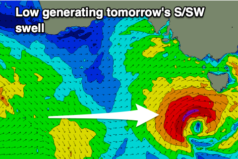
This final front has gone the way of EC's forecast last week, forming a stronger low just south-west of Tasmania with some further SW-S/SW energy due later today as winds shift W/SW.
This week and weekend (Jun 20 - 25)

We should see the surf building more in size this afternoon while shifting SW in direction and then easing back from the S/SW tomorrow, thanks to the final front on the backside of the Southern Ocean gyre (linked to the weekend's swell) forming a low directly south-southwest of Bass Strait.
A fetch of strong to gale-force SW winds is looking better than even EC forecast through last week and this will result in a moderate sized mid-period SW tending S/SW swell for later today and early tomorrow.
The Surf Coast should start easing back from 4ft+ tomorrow morning (5ft sets likely on the magnets) with 6ft sets to the east and conditions look good to the west with a moderate to fresh W/NW breeze, easing through the afternoon and likely holding.
The swell is due to drop quite rapidly through Tuesday evening with Wednesday easing back from 2ft+ at dawn on the Surf Coast, only a smallish 3ft+ to the east but with great winds for both locations. A local offshore N/NW breeze is due to the west, N/NE to the east, shifting N/NE across all locations into the afternoon.
The surf will bottom out into Thursday and the outlook into the weekend isn't great.
It's another weekend/early next week swell cycle but the coming progression will be even dicier than the one we saw last week.
It'll all be too far north and up over the continent with very flukey, weak fetches possibly falling within our swell window.

All in all I'd set the expectations low for this coming cycle, with the Surf Coast only likely to see slow 1-2ft waves (if that) on Friday from the initial early stages of the progression, south-west of Western Australia. Exposed beaches to the east look to come in more around 2-3ft but gusty N/NE winds for Thursday will shift strong N/NW Friday, creating average conditions.
Saturday looks smaller ahead of some possible small, localised W'ly swell generated by one of the fronts passing across us Sunday/Monday.
Following this mid-latitude activity it looks like some better Southern Ocean activity will fire up mid-late next week, but we'll have a closer look at this Wednesday.


Comments
$100 bucks says Wed is a absolute fizzler.
Easing, weak, mid-period south swell. Not ideal.
Swell is over-performing this morning which is always a plus.
Looks like its taken everyone by surprise, winki cam is very quiet!
It shouldn't be too much of a surprise, it was in the forecast last week and I had 4ft to possibly 5ft yesterday. Maybe a bit cold and everyone has gone to the snow ;p
pretty jumbled where i was a bit down the stretch but nice and solid - felt like the sets were pretty constant
Yeah fairly raw/lumpy, mid-period stuff mostly eh?
indeed, crazy the difference between this and last couple of similar swells which had the longer period
Could imagine. Still looks fun as from weak Sydney. Ha.
And here's why, a couple of storm-force barbs in the mix!
Yeah that was fun, a bit of kick and wild variations in tide made for choices and maybe some novelty. Not too many crew out, very cold start early with the clear skies.
Buller BOM obs got to -6.6 just before dawn, that's pretty solid effort for June.
http://www.bom.gov.au/products/IDV60801/IDV60801.94894.shtml