Windy weekend of new westerly swell
Victorian Surf Forecast by Craig Brokensha (issued Friday 16th June)
Best Days: Saturday, Sunday, Monday and Tuesday protected spots, Wednesday
Features of the Forecast (tl;dr)
- Moderate sized mix of W'ly groundswells building tomorrow with strong N winds, tending N/NW late
- Easing mix of swells Sun with strengthening NW winds, tending N/NW late
- Moderate sized, mid-period W/SW swell building Mon, peaking in the PM with strong W/NW-W winds
- Easing moderate sized mid-period SW-S/SW swell Tue with W/NW winds
- Easing swell Wed with N/NW tending N winds
Recap
Wednesday's small pulse of localised W/SW swell, generated by a cold front pushing through Bass Strait, eased into yesterday with clean but tiny waves on the Surf Coast, workable in selected spots to the east.
This morning is even smaller with a couple of options to the east of Melbourne for the desperate.
This weekend and next week (Jun 17 - 23)
Looking at the coming weekend, and we've got windy conditions with a mix of building, acute W'ly groundswells, with options opening up across both regions working the local winds.
It'll be tricky tomorrow with a strong N'ly breeze, shifting N/NW later afternoon along with a good, building W'ly groundswell.
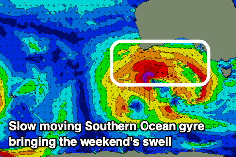
The source of this swell was multiple fetches of gale-force to at times severe-gale W'ly winds south of Western Australia, generated by a broad, slow moving Southern Ocean gyre.

The gyre is continuing to move east today while generating a less favourably aligned fetch of W/NW gales.
The gyre looks to weaken and break down on approach to us through the weekend, with weaker fetches of W/SW winds due to generate some smaller, reinforcing mid-period energy for Monday.
Coming back to tomorrow though and the best pulse of groundswell should fill in, building to 4ft on the Surf Coast into the afternoon on the magnets, 6ft+ to the east, easing back from 3-4ft and 6ft respectively on Sunday morning.
Winds will be more favourable for the Surf Coast reefs on Sunday and strengthening from the NW, tending N/NW on dark but more so into the evening ahead of a front clipping us early Monday, leaving W/NW-W winds into Monday.
The reinforcing mid-period swell should build back to 3ft to occasionally 4ft on the Surf Coast into the afternoon with 5-6ft sets to the east, then easing back from the same size range but with a more S/SW-SW direction Tuesday. This will be linked to the final front forming a low pressure centre just west of Tasmania on Monday.
Winds look great again Tuesday and out of the W/NW, shifting more N/NW to N'th on Wednesday as the swell eases.
Longer term a large cold outbreak is expected to push up and across the south-east of the country later next week, bringing some new swell next weekend as it moves east. At this stage it looks like it could all be a bit north to be favourable with small W'ly pulses on the cards but check back here Monday for a clearer idea. Have a great weekend!


Comments
sounds good to me!