Good run of surf from tomorrow
Victorian Surf Forecast by Craig Brokensha (issued Friday 28th April)
Best Days: Tomorrow Surf Coast, Sunday, Monday, Tuesday Surf Coast, Wednesday morning Surf Coast, Thursday
Features of the Forecast (tl;dr)
- Inconsistent moderate sized SW groundswell for tomorrow, mixed in with a close-range SW swell in the AM
- W/NW tending variable winds tomorrow
- Easing surf Sun with local offshore winds, N/NE-NE into the PM
- Building moderate sized W/SW groundswell with local offshore winds, tending N/NW-NW late AM and then S/SW-S into the PM
- Moderate sized mid-period W/SW swell for Tue, easing slowly later Wed
- Fresh W/NW tending W Tue, stronger W/NW tending W/SW Wed
- Easing surf Thu with N/NW-NW winds
Recap
Small leftovers across all locations yesterday with 1-2ft sets to the west and 2ft to occasionally 3ft sets to the east. Winds remained generally favourable into the afternoon for selected locations.
This morning we've got some new, building SW groundswell energy, with 2-3ft sets to the east and 1-2ft waves on the Surf Coast with workable early winds. We should see the groundswell build to 3ft into this afternoon but winds will strengthen from the NW ahead of a W/SW-SW change around midday, easing into the mid-late afternoon. This will create OK conditions for the keen later this afternoon.
This weekend and next week (Apr 29 – May 5)
Today's first pulse of building SW groundswell is expected to be followed up by a secondary similar size but less consistent swell tomorrow, generated earlier this week in our far swell window, to the east of the Heard Island region.

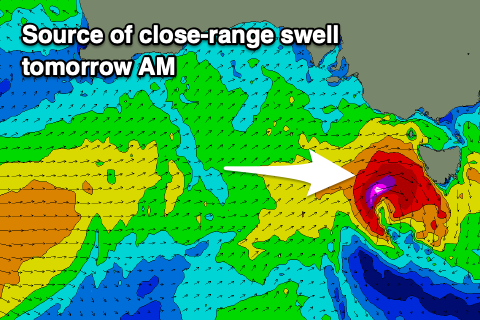
This should provide inconsistent 3ft+ sets on the Surf Coast and 5-6ft cleanups to the east, but we've got a more consistent, closer-range swell due to be in the mix.
This will be generated by a fast moving, tight and strong low dipping south-east through our swell window, west of Bass Strait today. We'll see gale-force W/SW winds generated though very brief in nature and this should produce more consistent 3ft waves on the Surf Coast tomorrow morning, 4-6ft to the east. There's likely to be more size overnight this evening when it peaks, though the trend will be down by dawn.
The swell will ease through the day with Sunday coming in smaller as the less consistent long-range groundswell drops, easing from a slow 2-3ft on the Surf Coast and 4-5ft to the east.
Locally winds tomorrow will favour the Surf Coast with a W/NW breeze, shifting variable into the afternoon. Sunday should be fun across all locations with light, N-N/NE winds to the east, N/NW on the Surf Coast ahead of variable N/NE-NE winds into the afternoon.
Now, moving into next week, we've got plenty of swell due thanks to a good Southern Ocean frontal progression firing up to the south-west of Western Australia.
An initial front swinging in from the south-east will generate a great fetch of NW tending W/NW gales, weakening and tending more W'ly south of the Bight. This will generate a moderate sized W/SW groundswell for Monday, filling in through the morning, peaking into the afternoon.
The Surf Coast should build to 3-4ft through the mid-late afternoon with 5-6ft sets to the east along with light, local offshore winds again (N/NE to the east, N/NW to the west), shifting N/NW-NW through the late morning ahead of a shallow S/SW-S change into the afternoon. This won't spoil conditions too adversely though.

Following the W/NW fetch, a broader and elongated fetch of strong to gale-force W/SW winds will project under Western Australia, generating a reinforcing pulse of mid-period W/SW swell for Tuesday afternoon/Wednesday, producing 4ft waves on the Surf Coast and 6ft waves to the east. At times there might be the random bigger one on the magnets but in general it should fall inside this size range.
Winds will favour the Surf Coast with a fresh W/NW tending W breeze due on Tuesday, stronger W/NW-W tending W/SW on Wednesday. The surf should ease slowly on Thursday but with great N/NW-NW winds.
Longer term we may see some new swell building into Friday but more so next weekend across the coast with winds out of the western to south-western quadrant, but more on this Monday. Have a great weekend!


Comments
Magic May begins ......
Forecasting notes getting increasingly briefer in nature... wonder if a twice weekly,( more in depth), forecast may work better.. appreciate the forecasts nonetheless.
Briefer? Lots of work put into this.
Jeez how much more info do you need?
Au Contraire.
More reports and much briefer please.
Tomorrow's surf report... Stay home. No good.
Copy / paste.
Saves Craig time and effort.
More waves for me.