Smaller, but fun swells for the coming period
Victorian Surf Forecast by Craig Brokensha (issued Friday 21st April)
Best Days: Today, tomorrow, dawn Sunday for the depserate, Monday, Tuesday and Wednesday on the beaches, Friday morning
Features of the Forecast (tl;dr)
- Smaller surf tomorrow with N/NW-NW winds ahead of weak sea breezes
- New pulse of SW swell Sun AM with dawn W/NW winds, shifting SW-S/SW mid morning, then S/SE
- Slightly stronger SW swell for late Sun, peaking Mon AM with N/NE winds (N/NW to the west in the AM)
- Smaller Tue AM, ahead of an inconsistent W/SW groundswell for the PM. Similar winds to Mon
- Easing SW swell Wed with fresh N/NE winds
- Smaller Thu with strong N tending N/NW winds
- Moderate sized SW groundswell building Fri with gusty N/NW tending W/NW, then W/SW winds
- Moderate sized S/SW groundswell Sat/Sun with gusty S winds
Recap
A mix of moderate sized W/SW and SW swell with great conditions on the Surf Coast yesterday, a consistent 4ft or so as winds shifted a little west into the afternoon, decent across semi-protected spots to the east.
This morning the swell is still there, though a touch smaller and with great conditions across most spots on the Surf Coast and 3-4ft sets, 4-6ft to the east with options for the experienced. Winds look to be favourable until a shallow S/SW-SW change moves through mid-afternoon along with a slow drop in size and consistency.
This weekend and next week (Apr 22 - 28)
The mix of swells seen through yesterday and today, generated by a progression of healthy storms through our swells windows this week, will ease off into tomorrow, but persistent, weak trailing activity should maintain 2ft to occasionally 3ft sets on the Surf Coast and 4ft to occasionally 5ft sets to the east.
Winds will be favourable and out of the N/NW-NW across both regions during the morning, giving into weak sea breezes.
We then look at our new pulse of W/SW-SW swell due on Sunday and it looks like EC has won out again, with the strengthening frontal system linked to it, now only due to generate a fast tracking fetch of W/NW gales.
This will limit the size, power and longevity of the swell with a quick spike due through Sunday morning before easing later afternoon.
Size wise the Surf Coast looks to be a touch more consistent and in the 3ft range, 4-5ft to the east and with dawn W/NW winds (SW to the east), shifting SW and then S mid-morning, S/SE into the afternoon. Winds will only be lightish so workable across both coasts through the day for the keen.
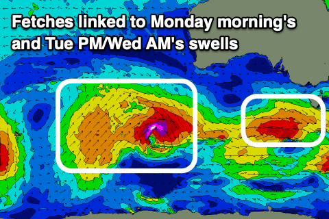
A secondary, strengthening frontal system will form south-west of us tomorrow afternoon, generating a burst of W/SW gales that should generate a reinforcing SW swell for Sunday evening, and Monday evening. This should maintain 3ft sets on the Surf Coast (possible rare bigger one), 4-5ft to the east before easing into the afternoon and further Tuesday.

Winds look favourable for both regions with, local offshore N/NE breezes to the east, N/NW to the west, shifting N/NE across all locations through the afternoon. Tuesday will play out similar with the swell on the ease through the morning ahead of a new pulse of W/SW groundswell after lunch.
The source of this swell will be a stronger but poorly structured low developing to the south-west of Western Australia on Saturday. The swell generating fetches around the low are tight and not overly sustained, with an initial burst of pre-frontal gale to severe-gale W/NW winds due to be followed by similar strength W'ly winds.
We should see a small-moderate, inconsistent W/SW groundswell arriving Tuesday afternoon and reaching 2-3ft across the Surf Coast with 4-5ft sets to the east, easing back from a similar size on Wednesday.
Freshening N-N/NE winds will favour the beaches on Wednesday as the swell eases, stronger N tending N/NW on Thursday.
Longer term, a strong progression of polar frontal systems through early next week should generate some moderate sized S/SW groundswell for Friday and next weekend, but a high moving in behind mid-latitude low pushing in from the Bight looks to bring poor S'ly winds. More on this Monday, have a great weekend!


Comments
has been good to finally get a bit of typical autumn swell. great yesterday and today with more to come :)
crowds have been crazy tho and hurry up and clear the carpark of all that comp stuff