Active period of surf from Wednesday afternoon
Victorian Forecast by Craig Brokensha (issued Monday 17th April)
Best Days: Today, tomorrow morning to the east, Surf Coast all day, Wednesday morning Surf Coast, Thursday, Friday Surf Coast, Saturday, Sunday
Features of the Forecast (tl;dr)
- Easing surf tomorrow with N/NE tending N/NW winds to the east, N/NW to the west
- Moderate sized, mid-period W/SW swell building Wed with moderate W/NW tending fresh W/SW-SW winds
- Peak in moderate sized W/SW and SW swells Thu with NW tending variable winds
- Slowly easing surf Fri with W/NW tending fresh SW winds
- Slowly easing surf Sat with light W/NW winds ahead of weak sea breezes
- New, inconsistent W/SW groundswell building Sun with W/NW tending S winds
Recap
The inconsistent W/SW groundswell seen into Friday which was a bit of an under-performer, didn’t hold too well into the weekend, with a reinforcing pulse hardly evident resulting in clean, but slow easing surf from 3ft on the exposed beaches to the east, with 1-2ft sets on the Surf Coast.
Yesterday was clean but tiny on the Surf Coast, bumpy to the east with a strong, afternoon SW change kicking up some localised SW windswell.
Today we’ve got a mix of mid-period energy and weak, easing windswell with great conditions on the Surf Coast with clean 2-3ft sets, workable to the east and to 4-5ft. Conditions will remain good all day on the Surf Coast but improve slightly to the east as winds ease but possibly tend more NW-W/NW. If we’re lucky they’ll just go variable.
This week and weekend (Apr 18 - 23)
Tomorrow will be a fun, small day for the beaches, with today’s mix of swells expected to back off under moderate, local offshore winds. A morning N/NE breeze is due to the east, N/NW to the west with winds shifting more N/NW into the afternoon across all spots. The Surf Coast will be smaller and easing from 2ft, with 3ft sets to the east.
From Wednesday through the end of the week we’ve got some fun, moderate sized W/SW swell energy due, though the direction will limit the size a little across the Surf Coast.

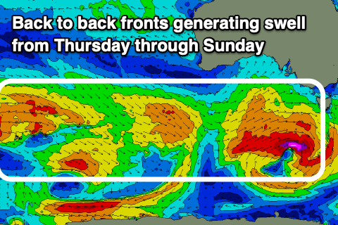
The first pulse of mid-period energy is due to build through Wednesday afternoon but peak early Thursday, generated by a strong mid-latitude front that’s currently south-west of Western Australia. A fetch of strong to gale-force W/SW winds have been generated, with the front due to dip slightly east-southeast tomorrow while pushing closer towards us.
A slight intensification of the storm, as it forms a low pressure centre will generate a burst of strong to gale-force W/SW winds more in our south-western swell window, then followed by a weak mid-latitude front pushing over the top of it on Wednesday.
All in all, Wednesday will start slow but build with small 2ft+ waves across the Surf Coast in the morning, 4ft to the east increasing to 3ft+ and 5-6ft respectively into the later afternoon.
Thursday at this stage looks to provide the most size, coming in at 3-4ft and 6ft+ respectively, easing slowly from a similar, if not slightly smaller size Friday morning.

Local winds will favour the Surf Coast thanks to the constant progression of frontal activity, with W/NW shifting fresh W/SW-SW winds on Wednesday as the swell builds, NW tending variable on Thusday and W/NW tending SW into Friday afternoon.
The swell will ease off further on Saturday, becoming weaker in period and smaller in size under a light W/NW offshore ahead of weak sea breezes. Winds should be light enough to offer a few options on the beaches into the afternoon.
A new pulse of W/SW groundswell is due to build Sunday, with further activity into next week as the Southern Ocean storm track remains healthy and active. More on this in Wednesday’s update


Comments
I'll take it !!! ..gotta start the season somewhere !
Last Fridays swell on the rock had a strong southerly/ SE direction to it with beaches facing due south receving angled swells from the SE
Long continuos lines when the sets came every 5 minutes or so.
Stretching from the Cape, through FC and along to SP.
Most crew struggled to find waves until mid arvo as the tide was low for most of the morning through lunch and the banks were not holding these long lines and a weird direction for the reefs that usually hold these swells.
Lots of crew and carpark afficiandos were all saying the same thing.
i googled afficiandos becasue i thought it was a type of coffee....it actually means someone that is into and knows a lot aboot car parks ...a bit weird.
funny ! No dis to RockyIsland
Should have included
'surf condition' between carpark and the hard to spell A word.
Every cRpark on every coast has them and we all know its the same conversation.