Fun beachy options early this week
Victorian Surf Forecast by Craig Brokensha (issued Monday 10th April)
Best Days: Tomorrow morning, Wednesday exposed beaches, Saturday exposed beaches, dawn Sunday beaches, Monday Surf Coast
Features of the Forecast (tl;dr)
- Easing S/SW-S swell tomorrow, with a new, inconsistent SW groundswell in the mix
- Variable tending SE winds tomorrow
- Smaller, inconsistent background swells for Wed/Thu with strengthening N/NE winds on Wed (easing later), strengthening SE on Thu
- Inconsistent, moderate sized W/SW groundswell arriving later Thu, peaking Fri with strong E/SE winds (possibly tending E/NE at periods to the east)
- Small SE windswell in the mix Thu PM and Fri
- Easing mix of inconsistent swells Sat with strengthening NE winds
- Smaller Sun with early, strong N/NE winds, shifting NW through the AM and then W/SW-W into the PM
- Moderate sized mid-period W swell for later Sun, peaking Mon with NW tending W/SW winds
Recap
Poor surf all weekend thanks to strengthening onshore winds and building levels of stormy, mid-period energy through yesterday, coming in large through the afternoon. The Surf Coast saw stormy 6ft waves, bigger to the east but with nowhere to recommend.
This morning the swell has lost its size and power with sloppy, junky 3ft leftovers on the Surf Coast and 4ft to the east.
This week and weekend (Apr 11 - 16)
We'll see conditions improve considerably into tomorrow across both locations as a broad, strong Tasman Low linked to the recent bout of onshore winds and stormy surf due to weaken and push east. This will see winds become variable through tomorrow morning across all locations, likely locally offshore in pockets though with plenty of leftover lump and wobble.
There'll be small levels of easing, weak S'ly swell and some new, inconsistent SW groundswell in the mix, with the latter generated by the earlier stages of the polar front linked to Saturday's change.
We should see infrequent 3ft sets on the Surf Coast magnets with 3-5ft waves to the east, easing back to a slower 2-3ft and 4ft respectively on Wednesday.
Wednesday looks best for the beaches with a strengthening N/NE breeze that looks to ease later in the day as a mid-latitude low pushes in from the east.
This low now looks to continue east, across us on Thursday bringing poor, strengthening SE winds that look to hold from the E/SE on Friday (possibly tending E/NE at periods to the east during the day).
Swell wise, background levels of inconsistent groundswell should maintain slow 2-3ft sets on the Surf Coast magnets Thursday with 4ft sets to the east, ahead of a new, long-range W/SW groundswell through the later afternoon.

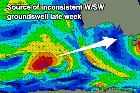
As touched on the last few updates, this groundswell and a follow up for Friday afternoon/Saturday morning are being generated by back to back lows projecting up from the Heard Island region, towards Western Australia.
An initial tight low is generating a fetch of gale to severe-gale W/SW winds, while a secondary system will push in on the back of the first though a touch smaller in scope.
Realistically it looks like both swells now will come in around the same size, inconsistent in nature and peaking to 3ft to occasionally 4ft on the Surf Coast magnets Friday, with 6ft sets to the east, easing from 3ft+ and 5ft+ respectively Saturday morning.

Winds will slowly improve and swing gusty NE on Saturday, favouring the beaches, with strong, dawn N/NE winds on Sunday swinging NW through the morning and W-W/SW through the day as a strong mid-latitude low starts edging in from the west.
Now, this low will form in the Bight this weekend, though the models diverge regarding its strength and swell generating properties. At this stage it looks a little suss, with a moderate sized, mid-period swell due to build later Sunday but peak Monday at this stage in the 3-4ft range on the Surf Coast and 6ft+ to the east. The American model has much more size and period.
Following this we might see some better swell generating activity developing through later next week, but tropical developments to our north are making any real long-range outlook tricky.


Comments
Note to self. I you see a decent swell/ wind forey on the horizon ignore it. 6 hours later it’ll be gone anyway.
I rarely pay much attention to the models these days, I find more often than not they are useless when it comes to winds, guess you can get a sense of an incoming swell from them at times (needs to be within 3-4 days to be confident), which is at least something. The notes are where the gold lies.
Excluding early March, 2/3rds of Autumn looking like shit again. Wonder if SC will ever return to his glory days.
We have had quite shite surf conditions of late . What happened to the Autumns I used to know?
The prolonged swell event seems to be a thing of the past.
And these gyre swell sources we have had with embedded lows seem to produce ridgy waves that snap boards.