Plenty of swell with decent winds to work around
Victorian Surf Forecast by Craig Brokensha (issued Monday 13th March)
Best Days: Tomorrow on the beaches, Wednesday afternoon, Thursday, Friday morning Surf Coast, Saturday morning, possible dawn Sunday
Features of the Forecast (tl;dr)
- Easing S/SW swell tomorrow with light, local offshore winds ahead of weak sea breezes
- Building moderate sized W/SW groundswell Wed PM, peaking Thu AM from a SW direction
- Mod-fresh SW winds at dawn Wed, easing and tending weak S/SE (likely variable), freshening later
- Gusty W/NW winds Thu AM, tending SW early PM
- Easing swell Fri with W/NW tending S/SE winds
- Fun mid-period SW swell Sat with strong N/NE tending N/NW winds ahead of a S/SW change
- Moderate sized mid-period SW swell building Sun, holding Mon with increasing S winds Sun (possibly variable at dawn), fresh S Mon
Recap
Fun waves across both regions through the weekend with clean options on the beaches to 3-4ft and a peaky 2-3ft on the Surf Coast.
The swell remained similar in size yesterday thanks to some reinforcing S/SW energy but besides for a period of early variable winds, conditions quickly deteriorated with a freshening onshore S/SW breeze.
Today winds are a little weaker but still onshore with bumpy 3ft surf continuing on the Surf Coast, 4ft to the east as our best pulse of reinforcing S/SW swell fills in.
This week and weekend (Mar 14 - 17)
Looking at the days ahead and we'll only see a temporary low point in energy before things pick up again from Wednesday afternoon.
Continuing on our active run of surf, the beaches will be worth targeting tomorrow morning as the current mid-period S/SW swell eases and winds shift light N/NE (N/NW Surf Coast) ahead of weak SE sea breezes.
The Surf Coast looks to ease back from 2ft to possibly 3ft, with 3ft sets to the east.
Early Wednesday morning will see the swell only temporarily bottom out and a trough will bring moderate to fresh SW winds at dawn, easing before shifting light S/SE into the afternoon.
This will result in improving conditions through the day instead of the other way around, along with a good pulse of new SW groundswell arriving mid-morning.

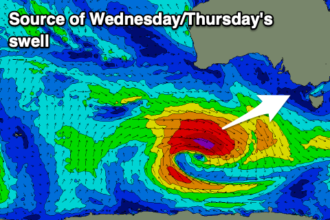
The source of this swell is a strengthening mid-latitude frontal system which projected towards Western Australia and is now deepening into a low off their south coast.
A great fetch of gale to severe-gale W/NW winds will be projected east-southeast through our western and then south-western swell windows, generating a moderate sized W/SW tending SW groundswell for Wednesday afternoon and Thursday morning.
The first W/SW pulse should build to 3-4ft on the Surf Coast Wednesday afternoon/evening, with 5-6ft sets to the east, while Thursday morning is likely to come in at 3-5ft and 6ft+ to the east respectively.
Winds on Thursday will be great for the Surf Coast and gusty out of the W/NW ahead of a SW change early afternoon as a cold front quickly pushes in from the west.
A small pulse of reinforcing W/SW swell is due from this source Friday, but not above the easing SW energy, with surf to 2-3ft due on the Surf Coast and 4-5ft to the east. Winds look favourable early and light W/NW, tending light onshore mid-late morning ahead of S/SE sea breezes mid-late afternoon.
Saturday will become windy as a small trough moves in from the west, bringing strong N/NE tending N/NW winds ahead of an afternoon S/SW change. There'll be some fun mid-period SW swell in the mix from weak frontal activity moving through our swell window, but this is expected to be seen more so through Sunday and early next week.
The Surf Coast should hold 2-3ft along with 4ft+ sets to the east.

From Sunday the swell will start picking up again thanks to broad, elongated Southern Ocean frontal progression developing east of the Heard Island region Wednesday evening, pushing slowly towards us through the end of the week and persisting through the weekend.
We should see moderate levels of mid-period SW swell building through Sunday, peaking Monday with the Surf Coast coming in at 3ft+ with 5ft surf to the east. Winds look dicey though as high pressure fills in from the west, bringing S'ly winds Sunday that may be variable at dawn, fresh through Monday.
Longer term, there's plenty more swell on the cards with lighter, more favourable winds but we'll look at this closer on Wednesday.

