Decent surf besides Friday
Victorian Surf Forecast by Craig Brokensha (issued Wednesday 1st March)
Best Days: This morning, tomorrow morning Surf Coast, Saturday from mid-late AM on the beaches, Sunday morning all locations
Features of the Forecast (tl;dr)
- Temp low point in swell tomorrow AM, ahead of a building moderate sized mid-period SW swell, peaking Fri
- Light W/NW winds tomorrow, tending S/SW late AM and freshening
- Gusty S/SE winds Fri
- Moderate sized S/SW groundswell arriving late AM Sat, peaking in the PM
- Pre-dawn, gusty E/SE winds Sat AM, easing and tending E/NE and then N/NE by late AM, giving into late sea breezes
- Easing S/SW swell Sun with N winds ahead of SE sea breezes
- Building windy surf next week
Recap
Monday afternoon provided plenty of size with a peak in SW groundswell but with poor, choppy conditions across all locations. The swell dropped back a touch into yesterday more to 3-4ft on the Surf Coast and 6ft to the east but with winds continuing out of the S/SW, fresh in nature.
Today, the swell is slowly easing from the 3ft range on the Surf Coast and 4-5ft to the east and lighter winds are creating workable options across most locations. Winds will freshen out of the SW and tend S/SW through the morning so make the most of the early clean conditions.

Decent conditions this AM
This week and next (Mar 2 - 10)
Looking at tomorrow, and a temporary low point in swell is due across all regions, but conditions will be clean across the Surf Coast with a light W/NW offshore, light SW to the east with 2ft to occasionally 3ft waves to the west and 4ft surf to the east.
Winds are due to shift S/SW and freshen from late morning along with some building mid-period S/SW swell, peaking through Friday.
The source of this moderate sized swell is back to back frontal systems firing up under the country the last few days. The first was weakest, while a secondary broader fetch of strong to sub-gale-force W/SW winds is now south-west of us, with the size due to build from later morning tomorrow.
An increase to 3ft+ is due through tomorrow afternoon on the Surf Coast and 4-5ft to the east, peaking Friday to 3-4ft (consistent 4ft magnets) and 6ft respectively.

Unfortunately conditions will be poor with gusty S/SE winds on Friday, much better Saturday and improving across the beaches as pre-dawn, gusty E/SE winds ease and tend E/NE and then N/NE later morning, variable early afternoon ahead of late sea breezes.
Size wise, the mid-period swell will start to ease, but a reinforcing pulse of stronger S/SW swell is due to arrive late morning, peaking into the afternoon.
This will be generated by a tight fetch of SW gales on the backside of the progression, south-west of Tasmania tomorrow.
This will likely keep the beaches a little too big to be user friendly to the east, but the morning high tide should help. The Surf Coast may ease temporarily on Saturday morning but pulse back to 3-4ft with the new swell, with 4-5ft+ sets to the east at the peak (more 4-5ft in the early morning).

Sunday looks super fun as a trough brings a return to light N'ly winds as the S/SW swell eases from 2-3ft on the Surf Coast and 4ft on the sets to the east. Sea breezes will create bumpy conditions into the afternoon.
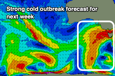
Longer term we've got a strong cold outbreak forecast for the south-east of the country into next week.
This will be a slow moving gyre of windy, cold weather, with multiple lows and fronts expected to be projected up and across Tasmania. At this stage the swell looks sizey but lower in quality, best in protected spots but we'll have a closer look at this on Friday.


Comments
Feels like La Nina has finally loosened its grip on our weather and surf. A lot more westerly quadrant winds, with swell and fronts moving through. Feb was better than average on the SC. More westerlies and swell next week by the looks. Hopefully a much better Autumn than the last couple.
Here's hoping Weatherman!
This morning the mid-period swell is in a bit earlier than expected. Bonus.
"Looking at tomorrow, and a temporary low point in swell is due across all regions, but conditions will be clean across the Surf Coast with a light W/NW offshore, light SW to the east with 2ft to occasionally 3ft waves to the west "
Definitely arrived early. Was pretty solid from dawn, some pretty solid sets where I was. A very pleasant surprise. Definitely felt more like 3-4ft with some pretty consistent 4fters that were rolling through. Hopefully a sign to come for the next 6 months!
love your work Craig, I nitpick, but is it possible to get headings for each day's commentary? Would make readability heaps easier if you have one day to surf can just flick straight to the good stuff
Agree with this! I've often thought it'd be easier to follow each day categorised
Back in the day we'd read the synoptic charts, look at the tide chart in the newspaper then we'd go outside and feel the wind and make a semi educated guess about where to surf. If we got it wrong, we'd try somewhere else or go home. I feel like we learned a lot. Sometimes it's better not to make things easier.
And after all that learning here you are now looking at a surf forecast report...seems sometimes it's better to develop new progressive and efficient ways of doing things wouldn't you agree?
I'm just here for the comments. BTW surf is fucked today. (I went and had a look). Slow and deliberate suits me better than progressive and efficient at my age.