Great outlook with lots of options
Victorian Surf Forecast by Craig Brokensha (issued Wednesday 15th February)
Best Days: Today on the beaches, tomorrow until late afternoon, Friday until the change hits, Sunday morning, Monday Surf Coast, Wednesday on the beaches
Features of the Forecast (tl;dr)
- Inconsistent W/SW groundswell for later this afternoon, peaking tomorrow, easing slowly Fri with a reinforcing SW swell
- Gusty N/NE winds tomorrow (N/NW in places to the west), giving into late sea breezes
- Strong N/NE winds Fri, tending N/NW early PM to the west ahead of a strong S/SW change mid-late PM
- Low point in swell Sat with early W/NW winds on the Surf Coast, mod-fresh SW tending stronger S/SW elsewhere
- Moderate sized W/SW swell Sun with light NW-N/NW winds ahead of SE sea breezes, then S/SW late
- Large SW groundswell building Mon with early W/NW winds, freshening from the S/SW
- Easing large swell Tue with mod-fresh S/SE winds
- Easing surf Wed with NE tending SE winds
Recap
The swell hung in around a fun 2-3ft across the Surf Coast yesterday with 4ft sets to the east and conditions were bumpy but workable for the keen in the morning, choppy through the afternoon.
This morning it's nice and clean across all locations (best on the beaches to the west) with a temporary drop in swell to 2ft and 3-4ft respectively west and east. A new, inconsistent groundswell should build into the afternoon but with sea breezes.

Great waves this AM
This week and next (Feb 16 - 24)
This afternoon's inconsistent W/SW groundswell was generated by a very distant but strong polar low that formed west of the Heard Island region. The swell hit Western Australia yesterday afternoon and is holding this morning, with it due to kick later today and peak tomorrow across our coasts.
Infrequent 2ft to occasionally 3ft sets are due on the Surf Coast magnets with 4-5ft sets to the east, but long waits for them.
Winds look favourable for all locations with a gusty N/NE offshore to the east, and pockets of N/NW winds to the west before sea breezes kick in late afternoon.
The swell is due to ease slowly through Friday, with a small reinforcing SW swell due to buffer the easing trend. Similar sized waves to tomorrow are due Friday morning, smaller into the afternoon and with a strong N/NE breeze, shifting N/NW early afternoon on the Surf Coast ahead of a strong S/SW change mid-late afternoon.
This change will be linked to a trough moving through, with moderate to fresh SW winds left in its wake Saturday morning, strengthening from the S/SW through the day. The Surf Coast will likely see early W/NW winds, but a low point in swell back to 2ft.

Moving into Sunday we've got a better looking pulse of W/SW swell on the cards, generated by a flurry of frontal activity south of Western Australia today and tomorrow.
An initial front today will create an active sea state for the secondary system with stronger, sub-gale-force W/SW winds moving in tomorrow afternoon.
Good 3ft+ waves are due off this activity on the Surf Coast (4ft sets likely magnets) with 5-6ft sets to the east.
Winds will swing back offshore out of the NW-N/NW Sunday morning with fresh afternoon SE sea breezes.
A weak trough will bring a S/SW change into the evening Sunday, improving Monday and reverting back to the W/NW ahead of a more substantial S/SW change (still only fresh).
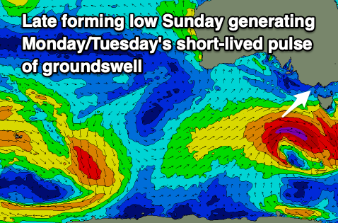
The swell is expected to drop temporarily into Monday morning, but we've got a strong pulse of fleeting large SW groundswell due into the afternoon, peaking overnight, easing Tuesday.

This will be produced by a significant low deepening south-west of us Sunday, with a burst of gale to severe-gale W/SW winds generated through our swell window.
The fast track of the low will result in a quick spike in swell, building to 5-6ft on the Surf Coast and 8ft to the east but with that S/SW breeze.
Easing surf from 4-5ft and 6ft+ respectively is likely Tuesday and with unfavourable moderate to fresh S/SE winds.
It looks like Wednesday will clean up rapidly as winds shift back to the NE along with easing levels of swell from Tuesday. We're looking at 2ft+ sets on the Surf Coast and 4ft waves on the exposed beaches.
Longer term a strong, slow moving low forming south-west of Western Australia should generate some good W/SW swell for next weekend, but we'll look at this closer on Friday.


Comments
Will take it Craigos, cheers! Will be Indo like vibes in the water next coupla days with the heat coming
Think I can see a 39 predicted for Melbourne on Friday on the Windy app... it's been a while since it's got that high (tho was away over Xmas). I can remember 43s on the coast years back, devil north winds circa 2009-12ish
edit: when Melbourne predicted 39 (5pm Fri), coast will be 25 after 34 @ 2pm - if the southerly comes in as predicted! :)
Ahhh it was fun surfing glassy waves again.
Are the forecast updates down ?, hasn’t seemed to update for last 2 days, WAM’s as well
Yep, trying to rectify as I speak.
I like it. It could be worth a paddle early next week.