Slowly easing surf with light morning winds (besides Friday)
Victorian Surf Forecast by Craig Brokensha (issued Wednesday 11th January)
Best Days: Today ahead of sea breezes, tomorrow morning, Saturday morning exposed beaches, Monday morning selected spots, Tuesday morning exposed beaches
Features of the Forecast (tl;dr)
- Slowly easing W/SW-SW swell with variable (light SW Surf Coast, variable E/SE to the east) tending S/SE winds tomorrow
- Moderate SE winds, strengthening through the day Fri
- Smaller Sat with E/NE-NE tending SE winds
- Strong S/SW tending S winds Sun
- Moderate sized mid-period SW swell Mon with E/NE-NE tending S/SE winds
- Smaller Tue with fresh NE tending N/NE winds
Recap
Improving surf through the day across all locations yesterday with a weaker offshore wind and building swell to 3ft across the Surf Coast and 4-5ft to the east. This morning the swell is starting to ease and winds have swung around to the E, creating cleaner, lumpy surf to 4ft on the exposed beaches. The Surf Coast is average and 2-3ft.
Winds should ease and tend more E/NE-NE through the morning before sea breezes start to develop early/mid afternoon, well worth making the most of.

Wobbly but good sized sets this AM
This week and next (Jan 12 - 20)
Looking at the coming days of surf and we'll see the swell size dropping slowly through tomorrow and Friday before bottoming out on Saturday.
The current mid-period W/SW swell will ease, slowed by some smaller, reinforcing SW energy tomorrow, generated by weak fetches of W winds under the Bight earlier this week.
The Surf Coast looks to ease from 2ft+ tomorrow morning with 4ft sets persisting to the east, smaller Friday with fading 1-2ft sets and 3-4ft waves respectively.
Local winds will be variable tomorrow morning, light SW on the Surf Coast and variable E/SE to the east before freshening from the S-S/SE through the afternoon.
Friday looks less than ideal with a moderate SE tending strong S/SE breeze due to create average conditions across most locations.

Saturday will improve across the exposed beaches with a light E/NE-NE morning breeze but small, leftover 2-3ft wave. The Surf Coast will become tiny.
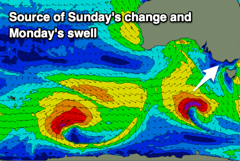
Looking at Sunday and we'll see a trough bringing a strong S/SW change before dawn, writing off the surf and beach for the day, though winds will quickly swing E and then E/NE-NE through Monday morning.
Some fresh mid-period W/SW swell should be in the water, generated by the earlier stages of the trough, that being a mid-latitude front passing under Western Australia Friday, dipping south-east while strengthening on Saturday.
The European model ECMWF has this being stronger than GFS, so we'll have to confirm the size on Friday but we're looking at 3ft waves on the Surf Coast Monday and 4-5ft sets to the east as conditions slowly improve.
Tuesday looks cleaner and more organised with a fresher NE tending N/NE breeze but smaller, easing surf from 2ft on the Surf Coast and 3ft to occasionally 4ft to the east.
Longer term winds look to deteriorate with another trough/strengthening low mid-late week, bringing swell but poor conditions. More on this Friday.


Comments
SE on the back beaches but could still here the people having a sick as time on their skis at the front beach around 130-330. Thought maybe still North on the bay but SC went South around same time
Razer reef was almost back to your pube sprouting days just after the low tide.
I’m just getting it done at puncture wound adjacent. Almost thinking about boardies for some tropical perfection.
Had family commitments through the best of the conditions today, so ended up going sailing to make the most of that SE wind. Dodging the fwits on ski's who were everywhere.
HNY folks. Heading to Merimbula with the family in a couple of weeks. Which surf report best lines up with that region? Is the 'Gong?
Love the banter in this group btw. Have fun.
Morning stsmith. There's a large distance between the Gong and Merimbula so there'll be considerable differences in size and conditions depending on the origin and direction of the swell source.
We've got a forecast for the region and that'd be a better representation of what to expect for the region IMO. https://www.swellnet.com/reports/australia/new-south-wales/merimbula/for...
Thanks Craig. Been a subscriber for a few years now and super happy with how you guys go about it and this type of interaction. Keep it coming!
I surf Gunna in the smaller, more manageable swells, and WP when the big stuff comes through. Although not as exact a science as I'm sure we'd all like (damn those dynamic weather patterns!) it gives me plenty of information to try and make a decent call on location and timing.
FYI - The tough one I find is when the swell is 4 - 5 ft at MP but just not big enough for WP so have to throw up the tea leaves and hope for the best.
All the best mate.
Than you for the support as well and good luck! There are lots of nooks and crannies to escape the bigger stuff if it picks up down there. Google Maps is your friend.