Very slow outlook
Victorian Surf Forecast by Craig Brokensha (issued Monday 5th September)
Best Days: Exposed beaches tomorrow morning, exposed beaches Thursday morning for the keen and patient
Features of the Forecast (tl;dr)
- Small mid-period S/SW swell tomorrow AM, easing with E/NE morning winds and gusty SE sea breezes
- Small SE windswell on the Surf Coast the coming days
- NE winds Wed, stronger Thu
- Inconsistent W/SW groundswell for late Wed, peaking Thu AM
- Weak W/SW-SW swell for Sat with W/NW tending strong SW winds
Recap
Average surf all weekend with a slow downwards trend in size and generally average winds. There were options for the keen but otherwise it was a grovel at best.
This morning winds have shifted a little more east of south, keeping conditions poor across the Surf Coast, average to the east and only for the keen.
This week and weekend (Sep 6 - 11)
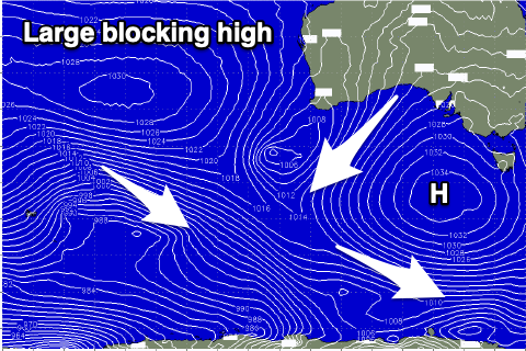
After a run of average conditions running from Friday through until today, we'll finally see a high that's been stuck to our west, moving further east today and over the coming days, bringing improving conditions across the exposed beaches in the state.
 Unfortunately the downstream effects of the high sitting so long to our west is that it's been deflecting any major swell generating systems away from us, resulting in the swell easing and bottoming out over the coming days.
A small, mid-period S/SW swell is due to arrive this evening, easing through tomorrow, generated on the backside of a strong polar frontal progression firing up under Tasmania.
Size wise, the Surf Coast looks to ease from 2ft+ tomorrow morning with 2ft to possibly 3ft sets to the east.
There'll also be some weak SE windswell across both coasts and an E/NE morning breeze will create peaky, clean conditions to the east ahead of gusty SE sea breezes.
Wednesday looks great surface condition wise with a NE offshore, likely lasting all day but with fading 1-2ft sets across both regions.
A small, inconsistent W/SW groundswell may be seen later Wednesday but Thursday is a better chance for this with the swell due to peak in the morning.
The source of this swell was a strong but not ideally structured low moving through the southern Indian Ocean and the Surf Coast isn't due to see any size at all, with an infrequent 2-3ft wave likely on the Mornington Peninsula and Phillip Island, easing through the day.
Winds will remain good for the beaches and strengthen from the NE, poor Friday and strong N tending N/NW with tiny surf.
Unfortunately the longer term outlook remains void of any major swell producing systems with a deepening mid-latitude low moving in from the Bight on Thursday/Friday (linked to the strengthening local winds) due to be too north to generate any swell for us.
Once the low moves across us Friday evening it looks to generate a weak 2-3ft wave out of the W/SW-SW Saturday on the Surf Coast, 4-5ft to the east and with W/NW tending SW winds as it moves across us.
A secondary, weaker low moving in behind this initial system looks to generate an additional S/SW swell for later Sunday/Monday but with S-S/SE winds.
Beyond this mid-latitude systems look to dominate but check back here Wednesday for the latest.


Comments
Crikey :-0