Workable waves over the coming days, improving early next week
Victorian Surf Forecast by Craig Brokensha (issued Wednesday 9th March)
Best Days: Keen surfers east of Melbourne tomorrow morning, similar Friday all coasts, keen surfers Saturday morning, selected locations Sunday morning, Monday through Wednesday mornings on the beaches
Features of the Forecast (tl;dr)
- Drop in swell tomorrow with moderate S winds west of Melbourne, variable (possibly) tending E/NE to the east, freshening from the S/SW from late AM
- Reinforcing mid-period SW swell Fri with moderate S/SE tending S winds
- Easing SW swell Sat with light S/S-SE tending fresher S/SE winds
- New moderate sized SW groundswell Sun AM with light E/NE tending S/SE winds
- Easing SW groundswell Mon with light E/NE tending S/SE winds
- Reinforcing SW swell Tue with NE tending S/SE winds, easing Wed with N/NE tending S/SE winds
Recap
Terrible conditions and surf across all locations yesterday with a strong S-S/SE breeze and reinforcing pulse of moderate sized SW swell.
Today our stronger SW swell has filled in but conditions are a mess across the Surf Coast, slightly better to the east but too large for the beaches.
This week and next (Mar 10 – 18)
We should see winds relax tomorrow as the low that's been hammering the southern NSW coast drifts off to the east. It'll be a tricky one though with moderate S'ly winds due across the Surf Coast, west of Melbourne, but to the east we're expected to see variable winds, even tending light E/NE.
This will create lumpy though cleanish waves with today's swell easing back a touch in size and intensity. Waves to 4-5ft are due on the Mornington Peninsula with 3ft surf on the Surf Coast. Winds will freshen from the S/SW during the day so try and surf before late morning.
Friday will then become bumpy with a moderate S'ly breeze persisting across the state along with a reinforcing pulse of mid-period SW swell. This is being generated by a healthy fetch of strong W/NW winds on the back of the low linked to today's swell and should kick the Surf Coast slightly to 3ft+ with 4-5ft+ sets on the Mornington Peninsula.
While bumpy, conditions should be surfable most of the day with the S'ly not really increasing in strength.
Moving into the weekend, winds will slowly improve further, being light out of the S/SE-SE on Saturday morning but around to the E/NE on Sunday morning.
Swell wise, Friday's pulse will ease into Saturday back from 2ft to possibly 3ft on the Surf Coast and 4ft or so to the east.
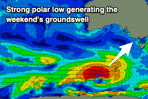
Our new pulse of SW groundswell for Sunday is on track, with a strong but tight polar low due to form south-west of Tasmania tomorrow, generating a fetch of gale to severe-gale W/SW winds. The swell will likely be a touch south of south-west but come in at a strong 4-5ft on the sets across the Surf Coast swell magnets, mostly 3-4ft across other breaks, with 6ft surf to the east, mixed in with the odd bigger cleanup.
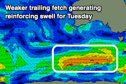
 Monday and Tuesday will likely be better surf days to the east of Melbourne as the swell eases and becomes more manageable. A light E/NE breeze is due again Monday morning with easing 3ft sets on the Surf Coast, 4ft+ to the east. A reinforcing mid-period SW swell should maintain 2-3ft waves on the Surf Coast Tuesday with 4ft+ waves to the east, generated by a weak fetch of W'ly winds trailing the low. Winds look great and light NE before sea breezes kick in, N/NE on Wednesday as the swell eases.
Longer term there's finally some possible stronger Southern Ocean frontal activity firing up south-west of Western Australia mid-late next week, generating swell for us the weekend of the 19/20th. More on this in the coming updates.


Comments
Anyone want to take a punt on when we might get a W / NW air flow?
Happy to see NE getting in the forecast but fearful we may go through autumn without any west or NW winds.
I'm going with 2023.
Read something this morning about La Nina being present until August so no reprieve to the wet conditions up north until then, which obviously sucks for more reasons than just ordinary surf.
Craig, if true does that mean winds from eastern quadrant down here too? Recall you mentioned something a while back saying the La Nina weather pattern should move away from us as it heads north
Where did you read that mate?
Think it was news.com.au but can't find the article now. Here is a different article, and this was the same guy being quoted, think news.com got confused by saying La Nina until August, that's not what he meant: https://www.abc.net.au/news/2022-03-05/when-will-the-rain-stop/100883168
He talks about La Nina until May, but then the wet months for up north starting in June so that's where he flags they won't get reprieve from the extended run of wet conditions until about August.
Cyclone season ends in April.... As it's always been