Generally poor apart from a couple of windows
Victorian Surf Forecast by Craig Brokensha (issued Friday 7th January)
Best Days: Sunday morning exposed beaches, Monday morning
Features of the Forecast (tl;dr)
- Strong S/SW winds tomorrow with a low point in swell
- New, small SW swell Sun with variable winds, increasing from the S'th through the day
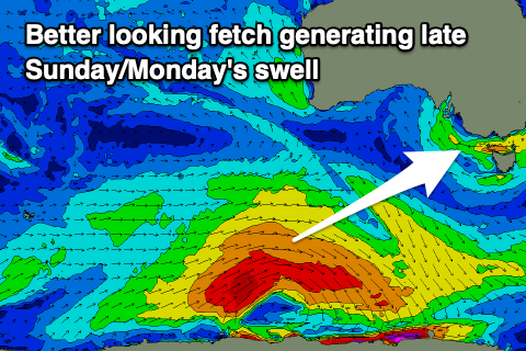
- Better SW swell arriving late Sun, peaking early Mon with light S'ly winds (possibly variable) freshening through the day
- Easing SW swell Tue with strengthening S/SE winds
- SE windswell Wed through Sun with strong SE-E/SE winds
Recap
Improving conditions across all locations yesterday with a mix of SE windswell and background SW energy, coming in at 3-4ft across most spots through the morning. We saw the beaches improve as the morning progressed and locations on the Surf Coast also improved as the SE energy faded.
Today conditions are clean across all locations with a smaller mix of swells easing from a weak 2ft+ on the Surf Coast and 2-3ft to the east. Conditions should remain good until mid-afternoon ahead of late sea breezes and then a fresher SW change into the evening.


Peaky, improving conditions through yesterday (AM and PM)
This weekend and next week (Jan 8 - 14)
Tomorrow will be a lay day as a trough pushes in this evening, bringing strong S/SW winds along with no new swell.
Winds should abate early Sunday morning and become variable from the S'th as the morning progresses, creating cleaner conditions but swell wise, only a small mid-period SW swell is due, ahead of a stronger kick later in the day and more so Monday.
 The source of these swells was a broad polar low forming south-west of Western Australia on Wednesday. An initial off-axis fetch of NW winds will generate Sunday's small swell, but a better, stronger fetch of strong to gale-force W/SW winds will produce Monday's swell.
Size wise, Sunday looks to be around 2ft on the sets across the Surf Coast and 3-4ft to the east, with the stronger swell kicking late to 3ft and 4-5ft respectively ahead of a peak Monday morning to 3ft+ and 4-5ft+.
The swell will ease through Monday and winds are looking light and possibly variable again out of the S'th before freshening through the day. So while not ideal, both days should offer OK waves for keen surfers.
Moving into Tuesday a new ridge of high pressure will start moving in from the west bringing freshening S/SE winds along with a drop in swell from Monday, strengthening from the SE on Wednesday kicking up a new SE windswell episode.
Unfortunately it looks like a deepening inland surface trough will squeeze the high through the rest of the week with no improvement in the local winds until Sunday next weekend. As a result we'll see persistent levels of moderate sized SE windswell along with strong E/SE-SE winds, creating poor conditions. Selected spots to the east may be workable late next week and weekend but we'll have a closer look at this Monday.
Fortunately these winds won't really spoil any quality groundswell from the Southern Ocean with it becoming quiet under the blocking pattern. Have a great weekend!


Comments
Hey thanks for all of your work Craig,
Curious what "An initial off-axis fetch of NW winds" is?
So not entirely NW but close?
And then how does that generate swell for Vicco?
I would have thought we could only get swell from the southern directions?
Oh, so I mean off-axis to Victoria's swell window. So like perpendicular and no good at all. If the fetch is W/NW in a certain part of the swell window it'll generate good swell that spreads up into Victoria.
Here it is, from Monday's notes..
Ah ok thanks - yep makes sense, Cheers
Fuck I miss your notes
Thanks Biggy.
Hey Craig, can you please confirm that back to back to back La Nina’s have not and will not ever occur..?
Two in a row is enough.
Us Victorians had a pretty good run the last 20 years and our parents had it even better 20 years before that. This so called la Nina event won't change for years, just hope it's not a 20 year long event. It's the way the weather works in this world. Takes a long time for the climate to go through different cycles.
Issues with the automated forecast?
Yeh has to be, certainly wasn't 0.5ft out there this morning... think it kept some of the crowd away though. Fun morning.
Yeah the wave model stopped for a couple of days from last Friday so missed out on the swell generated yesterday and today once it kicked off again. Hence the value of the notes :)
True that Craigos, keep up the good work!
Why do the forecast models not even list the SW swell for Sun/Mon? Says 0.5 SE swell.
As above.