Upgrade in the coming mix of westerly swells
Victorian Surf Forecast by Craig Brokensha (issued Wednesday 1st December)
Best Days: Today, Friday for the keen working the onshore winds, dawn Saturday protected spots, Monday on the beaches
Features of the Forecast (tl;dr)
- Low point in surf tomorrow with variable SW winds, strengthening through the afternoon/evening
- Building inconsistent W/SW swell Fri with a stronger pulse of W/SW groundswell arriving later in the day. Light-mod S/SW tending S/SE winds
- Easing W/SW groundswell Sat with strong SW winds (likely lighter and W'ly for a period early on the Surf Coast)
- Easing surf Sun with fresh S/SE winds
- Easing swell Mon with NE tending variable winds, smaller Tue with a freshening SW breeze
Recap
A fun day of waves on the beaches yesterday with an inconsistent SW swell that spread off the W/NW fetch we've been discussing the last couple of updates. The Surf Coast magnets were 2ft+ with 3-5ft sets to the east and favourable winds all day.
This morning early the swell was still 3-4ft on the exposed beaches but it's since dropped and filled up with the big morning tide, with leftover 1-2ft sets on the Surf Coast.


Good waves to the east yesterday afternoon and this morning
This week and weekend (Dec 2 - 5)
The end of the week isn't too flash overall surf wise, but winds are now looking more workable into Friday along with an upgrade in swell.
Firstly tomorrow will see the swell drop further in size, bottoming out on the Surf Coast and coming in at a slow 2ft or so on the Mornington Peninsula. A weak trough moving in from the west looks to arrive possibly a touch earlier bringing variable SW winds, strengthening through the day and especially into the evening. This trough arrived earlier than expected in South Australia this morning so it'll be interesting watching its evolution as it moves in towards us.
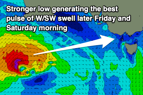
We then look at our mix of W/SW swells into Friday. The source of these swells is effectively the same frontal progression, with an initial polar low developing in our far swell window on the weekend, then weakening as a secondary intense low fired up on the backside of it today, south of Western Australia.
 The initial polar low generated a great though distant fetch of W/SW-W gales and this should produce an inconsistent 3-4ft of swell for the Surf Coast Friday afternoon and Saturday morning, with 5-6ft sets to the east.
The secondary low firing up south of Western Australia today is looking stronger and will generate a more consistent but more westerly angled swell for later Friday and more so Saturday. With a fetch of gale to severe-gale W/SW winds projected towards us, on top an active sea state we'll hopefully see a touch more size pushing in later Friday to a more consolidated 4ft+ on the Surf Coast, 6-8ft to the east.
Saturday should then offer similar sized waves, easing through the day, smaller and dropping from 3ft on the Surf Coast Sunday and 4-5ft to the east.
Coming back to the local winds and tomorrow's strengthening SW winds into the evening are due to abate into Friday morning, easing back to light to moderate but out of the S/SW tending S/SE. While not ideal there should be some OK options with the building swells through the day.
Saturday looks generally poor with a strong SW'ly, but a local trough looks to tip winds W'ly for a short period on the Surf Coast around dawn, creating OK waves for the keen. Unfortunately Sunday will be poor with fresh S/SE winds as the swell eases.
Next week onwards (Dec 6 onwards)
There'll be a window of clean conditions across the beaches Monday before another trough brings onshore winds into Tuesday and the swell will be easing from a fun size. A morning NE'ly is due to tend variable through Monday with easing 3-4ft sets on the Mornington Peninsula, fading from 2ft on the Surf Coast. Make the most of this as Tuesday looks smaller with a SW'ly.
We should see some new, small-moderate sized mid-period swell for mid-late next week with workable westerly winds but we'll have a closer look at this on Friday.


Comments
That low in the Bight intensifies very impressively next Monday.
Not if keeping an eye on the EC model and the latest 18z GFS update though.. I'd put it as an outlier.
You took the words etc ...
Some nice rumbles rolling across the bay at the moment.
A couple of huge thunder cells in the Bay at present. The S'ly breeze here is feeding into them.
Looks awesome from here.
Can just spot them on the St Kilda cam.. https://www.swellnet.com/surfcams/st-kilda
Proper Bintang conditions now!
Very Indo-like to the east late yesterday. Amazing surface conditions, warm, a good size, lots of lines pouring through and a very good bank.
Epic!
Some cool observations this morning.
Early with the land breeze (which is lower in humidity and has a lower dew point) conditions were clear and sunny, but the trough has brought in moist, cooler air with a higher dew point.
When air temp reaches or gets below the dew point we see the air become saturated.
So the cooler change along with the cooler ocean temperature has cooled the air to the dew point, causing condensation/sea fog on the peninsula.
It's clearing over the bay side though as the water temperature and air above it is warmer than the dew point, so there's no condensation occurring.
Sorry, bit confused. How does 'the trough has brought in moist, cooler air with a higher dew point' match up with 'So the cooler change along with the cooler ocean temperature has cooled the air to the dew point'?
Oh sorry it should be more so the cooler sea surface has cooled the moister air. I made a bit of a meal of that.
Gotcha, thanks!