Good to great surf developing from late week
Victorian Surf Forecast by Craig Brokensha (issued Monday 9th August)
Best Days: Protected spots Thursday through Sunday
Features of the Forecast (tl;dr)
- Fading swell energy tomorrow, bottoming out Wed with strong N winds tomorrow, strong N/NW Wed
- Inconsistent W/SW groundswell for Thu AM, with a similar sized, slightly more consistent mid-period W/SW swell for the PM
- Moderate to fresh NW winds Thu, stronger N/NW tending W/NW Fri as the swell eases
- Mod-large W/SW tending SW groundswell building Sat with fresh NW tending W/NW winds, easing Sun with NW winds
Recap
Our stronger, larger SW groundswell for Saturday filled in on schedule with good, clean 4-6ft waves on the Surf Coast magnets, bigger to the east, but cleanest in protected spots.
Yesterday saw the swell slowly easing with more favourable winds opening up lots of options across the state, best on the beaches into the afternoon.
Today, the surf is easing further and winds are ideal for the beaches so get stuck in before it drops more.
This week and weekend (Aug 10 - 15)
Down, down, down. That's the trend over the coming days with late last week's and the weekend's swell due to continue to ease further tomorrow before bottoming out Wednesday morning.
Winds will also strengthen as a vigorous, though weakening mid-latitude frontal system approaches from the west.
Strong N'ly winds are due tomorrow with the swell easing from a slow 2ft on the Surf Coast and 3ft on the Mornington Peninsula. Wednesday will be even smaller and with strong N/NW winds, there'll be nowhere to recommend.
 Now, very late in the day a new long-period signal should be seen, with the bulk of the groundswell due to fill in Thursday.
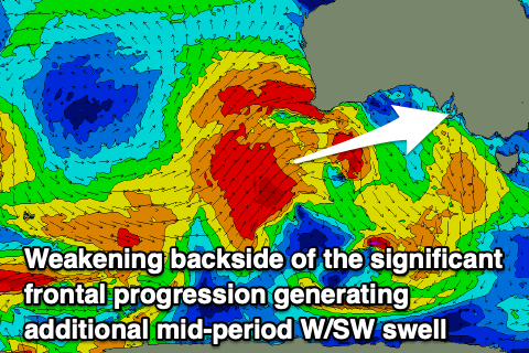
The source of this swell was a significant polar frontal progression firing up towards Western Australia over the weekend, through our long-range western swell window.
This progression is now pushing up and across Western Australia while weakening, with a secondary fetch of gale-force tending strong W/SW winds due to push through our medium to close-range swell window today, tomorrow and then Wednesday.
This will generate some additional mid-period W/SW swell for the afternoon Thursday which will be more consistent than the long-range groundswell energy.
 So Thursday morning should come in at an infrequent 3ft, with 4ft sets on the swell magnets across the Surf Coast, 5-6ft+ to the east. The afternoon looks more consistent and similar in size, 3-4ft on the Surf Coast and 5-6ft+ to the east.
Winds will will be favourable and out of the NW all day Thursday, favouring protected spots, with Friday seeing stronger N/NW tending W/NW winds as the mix of mid-period and groundswell energy ease.
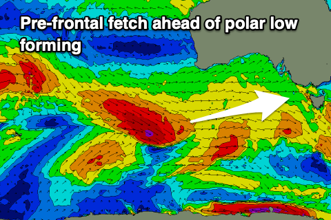
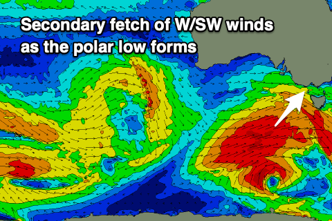
Moving into Saturday a new, moderate-large sized W/SW groundswell is due to fill in, generated by a great pre-frontal fetch of W/NW gales moving in behind the weakening mid-latitude frontal system, south-west of Western Australia. The front will spawn into a low with better aligned gale to near severe-gale W/SW winds projected through our south-western swell window.
 The swell looks to start W/SW Saturday morning, shifting SW through the day and building from 3-5ft on the Surf Coast to the 5-6ft range into the afternoon, with building surf to 8ft on the Mornington Peninsula.
Winds will be great for protected spots and NW tending W/NW on Saturday with NW winds all day Sunday as the swell eases.
Longer term we've got smaller surf though fun reinforcing S/SW groundswells through next week from persistent polar frontal activity under the country but more on this Wednesday.


Comments
I might chuck a couple of sickies.
Gary recommends against this approach:
https://www.illawarramercury.com.au/story/7373753/wollongong-man-charged...
Oops.
It's not the Covid that ails me.
It's me brain meats have gone all gloopy from bein all locked up.
Need some sunshiney rays, a good ole nose flushin and a salt water enema to set me right agin.
mmmmm enema.
Ha, couldn't he have just said he has covid symptoms and got tested, then had the 72 hours off in isolation?
Geez Victoria's getting some good exposure here lately.......
What about the other states? Surely there's gotta be stuff worth reporting on West/South/East/North of here???
Those other states don't have posters with such awesome banter.
Boring fuckers prefer discussing swell angles and periods rather than calling each other carnts and taking the nuclear option.
Haha
Carnts
Bone when it's a left just go left, although ya did a pretty impressive turn onto the rocks.
Haha, tell more.
Bone doesn't like to go left, there was an ok left at Porta last night and he was trying to go right. I think it's a throwback from when he was a boogie boarder.
Hahaha. Classic.
But’s rights are right, that’s why their called rights, right?
some rights aren’t quite right, right. Maybe i’m not quite right.
But if the rights aren’t quite right, all we’re left with is lefts. Thats not right nor is right. Lefts are just better left alone, am I right?
Not sure if you are right or not quite right but what about the rights that are off the left that is where the injector left was but are lefts that are behind the left that was the rights off the left which are slightly left of center which isn't quite right, that was Sunday night, heard it was like backdoor pipe.
Yeah fucked it by going porto. Had to go left on the lefts. No rights, just a river rapid alright.
Was a heap of fun that rip bowl left.
Sunday the 15 th still looking like the best day as I predicted just need the wind to play ball
It doesn't look any better than the weekend just gone.. Also the swell is from a low firing up under the country, not from the Indian Ocean as you said..
"Jeez if your calling Friday onwards a good run you'll be frothing from Sunday the 15 th onwards. Long range forecast looking good"
"The lows forming off Antarctica next Wednesday directly between South Africa and Oz look way more intense than yesterday"
And you said from 15th onwards, but again it's just one day on the 15th with the easing swell, then just another fun run.
So yes good, as but similar to what we've had, and nothing like you predicted.
Ah this is just the start of winter though. I was about 1 day behind with my prediction but it don't matter. That low in the Indian Ocean is helping the next mid lat low to do it's thing. This is how LWT work, back to back lows intensifying each other. So Sunday 6-8foot winki, Monday won't be much smaller. Sounds better than last satdau if I've been waiting for the purple blobs.
There was some amazing waves on Sunday from that last one Craig down this way.
Awesome, thought it would be great, some of the comments on the previous notes were at odds to it, but I take them with a pinch of salt ;)
Like a lake but still such a beautiful place to defrag.
Defrag, haha, haven't heard that for ages.. Great word to describe immersing, unwinding and refreshing.