Fun end to the week, large swell next week
Victorian Surf Forecast by Craig Brokensha (issued Wednesday 28th April)
Best Days: Friday and Saturday morning on the beaches, selected spots Tuesday and Wednesday
Features of the Forecast (tl;dr)
- Building W/SW-SW swell late tomorrow, peaking Fri with N/NE tending NE winds, easing Sat with strengthening N/NE winds
- Large, long-period W/SW-SW groundswell building Mon PM, peaking Tue AM but with strong S/SW tending weaker S/SE winds, easing Wed with SE winds
Recap
Fun, easing surf from the 3ft on the sets across the Surf Coast yesterday morning, 3-5ft to the east with workable, lighter winds. Today we've got clean conditions across all locations but easing 2ft waves on the Surf Coast, 3ft and glassy to the east.
This week and weekend (Apr 29 – May 2)
The surf will continue to ease today and into tomorrow morning, reaching a low point ahead of a new, inconsistent W/SW swell into the afternoon, but more so Friday.
 Conditions will be clean again in the morning across all locations with light local offshore winds, but the Surf Coast looks to be tiny and to 1-1.5ft or so, 2ft+ on the Mornington Peninsula.
Winds will shift onshore into the afternoon, and our inconsistent W/SW swell from distant, patchy frontal activity should start to show. Friday is still the pick for surfing with the swell peaking and having a small SW component, coming in at 2-3ft across the Surf Coast and 4-5ft to the east.
Winds are looking good most of the day with a moderate N/NE breeze, likely easing and tending NE into the afternoon favouring the beaches.
Saturday will be clean on the beaches again though windy with a strengthening N/NE breeze and easing surf from 2ft west of Melbourne, 3ft to occasionally 4ft to the east.
A weak change is due Sunday but there'll be no real swell generated behind it, with a brief burst of W'ly winds generated in our western swell window.
Next week onwards (May 3 onwards)
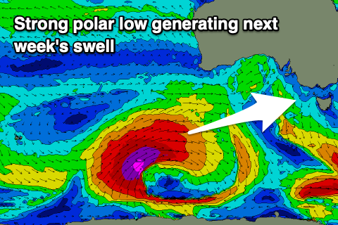
Monday will start slow but into the afternoon a strong, long-period W/SW-SW groundswell will start to build, peaking Tuesday morning. The source of this swell will be a strong polar low firing up around the Heard Island region this evening, generating a great fetch of severe-gale to storm-force W/SW winds while moving slowly east through our swell window.
 The low will continue with strength until south of WA Saturday morning, then easing while continuing slowly east. This will result in a large groundswell, with it peaking Tuesday morning to the 6ft to occasionally 8ft range across the Surf Coast magnets and 8ft+ to the east, but we're unfortunately due to see strong S/SW tending S/SE winds as a trough moves through Monday.
The trough looks to form into a low off Eden keeping poor SE winds blowing into Wednesday as the swell eases, E/SE on Thursday.
Winds look to improve late week with some new swell on the cards, but more on this Friday.


Comments
What was the video of?
Haha it was deleted off YouTube, knew it wouldn’t go down well as soon as I saw it. Vid of a relatively quiet island on the pump, filmed by an exploitative SC photog. You would have seen most of it before, been all over IG past 2 weeks
Ohhh yes I see.
Photog maybe getting asked nicely by island locals to remove it?
How I love her but cannot speak of it
Any reason to all the kelp at the moment. Portsea, if it was to have a shorie, would be fucked. Most I’ve ever seen. Came after the big swell the other weekend fortnight or so ago. My theory is that it’s brought in from way out with the big swells disturbing below much further out?
Yep that happens often in Geraldton WA - swell action rips weed off the outer reefs, deposits on the back beach/Separation, Bluff Pt etc
I saw a lot of sea weed loose in WP last week with the big swell on 23/4/21. I might go for a paddle down there tomorrow. Maybe the tides have cleaned it up a bit?
It’ll be flat mate
Yup.