Easing swell size and power as winds slowly improve
Victorian Surf Forecast by Craig Brokensha (issued Monday 8th)
Best Days: Keen surfers Friday, beaches Saturday morning, keen surfers Tuesday and Wednesday mornings
Features of the Forecast (tl;dr)
- Easing SW groundswell tomorrow with SE winds, smaller Wed with fresh E/NE tending SE winds, tiny Thu with strengthening N/NE winds
- Small SE windswell late tomorrow and Wed, tiny Thu
- Weak W/SW swell for Fri PM with S/SW winds, easing Sat AM with an early W/NW breeze on the Surf Coast
- Better W/SW groundswell for Sun PM but with S/SE winds
Recap
Friday's inconsistent SW groundswell was still a good size Saturday morning with clean, 4-5ft+ sets on the Mornington Peninsula, 3ft on the Surf Coast magnets, easing through the day as winds shifted more W/NW, favouring protected spots.
Yesterday was smaller and onshore with choppy, poor waves across all locations.
A mix of mid-period and inconsistent, new SW groundswell have filled in today but fresh S'ly winds are creating poor conditions, with nowhere to really recommend for a surf.
This week and weekend (Feb 9 - 14)
Today's inconsistent SW groundswell, which was generated by a distant, though strong polar low east of the Heard Island region last week, will ease off through tomorrow, further Wednesday as winds slowly improve for the beaches. The Surf Coast will ease back from 2-3ft, with 4ft sets to the east.
Conditions still look poor with a moderate SE'ly (fresh across some spots), strengthening late in the day from the E/SE. A small SE windswell will be whipped up from the brief burst of winds overnight, more so on the Surf Coast, with peaks put through the easing swell on the Mornington Peninsula and Phillip Island Wednesday.
Size wise the Surf Coast looks to drop from a peaky 1-2ft Wednesday, with peaky 2ft to possibly 3ft sets on the Mornington Peninsula under a fresh, morning E/NE breeze ahead of SE sea breezes.
 Thursday will be cleaner again as winds strengthen from the N/NE through the day, but the surf looks tiny.
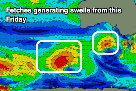
Our next increase in swell will originate from a weak mid-latitude low moving in from Western Australia, under the country. This low should produce a small fetch of strong W/SW winds while projecting east mid-late week, clipping us Friday.
This will bring a W/SW-SW change Friday morning though only light, ahead of strengthen S/SW winds into the afternoon as the new mid-period W'ly swell fills in.
We should see 2ft+ sets developing on the Surf Coast, 3-4ft to the east, easing Saturday under similar winds (likely W/NW early on the Surf Coast).
A better W/SW groundswell is due Sunday afternoon from a stronger polar front firing up not too fat behind the mid-latitude low, with a fetch of W/SW gales likely to generate 3ft+ sets on the Surf Coast, 4-5ft+ to the east.
Winds aren't looking too favourable at this stage and out of the S/SE, freshening Monday. We'll likely see better conditions Wednesday with a possible fun, new swell, but more on this in the coming updates.


Comments
Groundhog week !
Same Same but even Badder.
Not much to become excited about or get motivated to drive to the coast for either. Again ! .I am waiting for Autumn to kick in at my usual protected spots for surfing when surfing conditions usually improve with NW winds and better long period swells.
Hit the open beaches first light Thursday T, before it gets too full.
You'll get a few little peelers.
I went for a paddle at a spot on the Surf coast today. It was better than nothing!!
What a shitfest the past 6 months has been down here.
Worst Run
EVER...............
I can't wait for March 1st when everything is right again in the world with NW winds and long period groundswell*
*Praying everyday to Huey to give us something!
So the surf is no good if it ain’t offshore?
Maybe relocation is the answer - https://www.rapturecamps.com/blog/the-waves-in-nicaragua-are-always-offs...
Ha,
That was a pretty funny read.
How's the promo shot of the bloke copping the lip in the head for becoming a surf instructor. Classic
Haha