Poor weekend, a couple of options next week
Victoria Forecast by Craig Brokensha (issued Friday 30th October)
Best Days: Exposed beaches Monday morning, Friday morning
Recap
Conditions finally cleaned up yesterday, but as expected, there was no swell left with any size or power. Just a very weak, tiny leftover south-east windswell.
Today an inconsistent W/SW groundswell has filled in with moderate onshore winds. The beaches to the east are OK for the desperate but other than that it's another lay day.
This weekend and next week (Oct 31 – Nov 6)
Unfortunately the weekend will continue the trend of poor surf with onshore winds and a slight drop in inconsistent W/SW groundswell from today, mixed in with a small mid-period SW swell for Sunday.
Winds tomorrow will be moderate to fresh out of the S/SE, freshening from the S/SW through the day, moderate S/SW tending S/SE through Sunday.
Size wise the Surf Coast looks to be around a small 2ft, with 3-4ft sets to the east most of the weekend.
Monday looks the pick of early next week as winds finally shift offshore out of the E/NE-NE through the morning with Sunday's small mid-period SW swell due to ease from 1-2ft across the Surf Coast, 3ft on the sets on the Mornington Peninsula. Surf before early afternoon as sea breezes will kick in as the swell drops further.
Tuesday will be clean again but tiny with a moderate to fresh N/NE breeze. Wednesday the same as the swell bottoms out and winds shift from NW to SW.
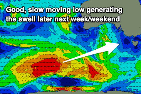
Looking at the slow moving polar storm that's due to develop this weekend and the intensity has been backed off just a touch but the longevity increased as it edges closer towards us early next week.
 The low will form in our far swell window, generating a good, slow moving fetch of W/SW gales, pushing further east while slowly weakening Monday but persisting through Tuesday.
This should create an inconsistent, moderate sized SW groundswell event that'll be prolonged but lose power on the back end owing to the weakening of the fetch as it moves closer towards us.
The swell is due to arrive Thursday, right when a surface trough moves through, bringing poor, gusty S'ly winds, abating through the day and swinging S/SE.
The Surf Coast should build to an inconsistent 4ft through the afternoon with 6ft sets to the east, backing off slowly from 3-4ft and 5-6ft respectively morning. Winds look to become more variable out of the E on Friday morning ahead of sea breezes so there should be a few options for a surf.
The models diverge on a strong cold outbreak projecting up from the south-west later week and those winds for Friday morning, but in any case Saturday should see stronger NW offshores ahead of a front and W/NW change as the SW mid-period energy eases from 3ft on the sets across the Surf Coast, 4-5ft to the east.
Some new swell energy is expected from the cold outbreak later next weekend and into the following week though with dicey winds. We'll have a closer look at this Monday. Have a great weekend!


Comments
Monday should be a little taste of things to come
Yep, I'm also actually going to go and hunt a bank dare I say it, will I be lucky or will it just be a straight-hander skunkfest.........
Fortune favours the brave... not sure Huey does though.
Looks like a sweet swell ready to hit 11.59pm on the 8th.
Correct Patrick0710. Woo hoo!
Yes and my word it will be busy on the 9th. Possibly crazy busy :-0.
Fascinating viewing while the surf's shit down there peninsula crew.
https://www.abc.net.au/news/2020-11-01/disappearance-harold-holt-inside-...
Pretty nuts eh. My moneys on shark victim
The Russians!!! haha. They spotted a noah too...looked pretty big and washy that day but who knows. No body found....