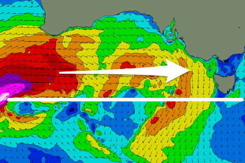
West and over-forecast
Victoria Forecast by Craig Brokensha (issued Monday 29th June)
Best Days: Desperate surfers exposed beaches tomorrow, less so Wednesday, Friday, Saturday morning
Recap
Our new mid-period W/SW swell seen later Friday peaked Saturday morning with clean, fun 3ft waves on the Surf Coast, 4-5ft sets to the east and with favourable winds most of the day.
Yesterday was smaller and best across the exposed beaches across the state with northerly breezes.
Today the swell is smaller again, tiny on the Surf Coast with clean and small waves for the keen on the Mornington Peninsula.
This week and weekend (Jun 30 – Jul 5)
The surf will remain small to tiny and slow across the coast over the coming days as winds strengthen out of the N/NE-NE ahead of an approaching mid-latitude frontal progression.
The Surf Coast is due to remain tiny, and the small pulse in size showing on the charts is from very long-range energy that'll have no size or consistency. Expect mostly waves to 2ft on the Mornington Peninsula and Phillip Island magnets, with very rare bigger one. The wind will be more fresh than strong tomorrow, though stronger Wednesday.
We then look to the strong mid-latitude frontal progression that's currently projecting up and into Western Australia, under the influence of a strong node of the Long Wave Trough.
 The current activity is too north of our swell window to generate any size at all, but a strong low that's forecast to form east of Heard Island is now due to form further north as well, and south-west of WA. This isn't ideal either and while wind strengths will be severe-gale to storm-force the track of the low will be to the north, falling just within our swell window (right). As a result no significant size is expected for the Surf Coast.
The models are really struggling with this and over-forecasting the initial size, so use the notes as a much better guide, not the graphs.
What we're expected to see instead is weaker mid-period energy from the low as it weakens and dips south-east through our swell window Thursday. A fetch of strong but weakening W/SW winds will kick up a building windswell Thursday afternoon from a tiny start, while the acute W'ly groundswell from the low is also due to start showing late in the day, though a peak is expected Friday.
The Surf Coast may see sets to 2ft to possibly 3ft by dark Thursday (tiny early), 4-5ft or so to the east along with fresh and gusty NW-W/NW winds. Friday should provide more size and action though to a very inconsistent 3ft to possibly 4ft on the Surf Coast swell magnets (smaller elsewhere) and 6ft+ to the east.
Conditions should remain favourable most of the day with a gusty N/NW-NW breeze, shifting more W/NW through the afternoon ahead of a late SW change.
The change will be shallow and not associated with any decent reinforcing swell energy, with Saturday expected to ease back in size from 2-3ft, 4-5ft+ to the east. Winds should tend back to the W/NW for the morning, W/SW through the afternoon.
Sunday isn't too flash with leftover mid-period SW swell energy and a general wind flow, W/NW for a period across the Surf Coast early.
Longer term some new W/SW swell is on the cards for early next week generated by unfavourably tracking and aligned frontal activity from the Indian Ocean. Size wise it looks fun and winds could be favourable from the W/NW, but we'll have a closer look at this on Wednesday.


Comments
Define shallow?
For your region, fresh to strong but short-lived.
Lurvely..
How good is summer! Oh wait...
Craig did the computers get the binary codes in a knot as I read a 19.8 second 2 foot swell for Monday. Powerful 2 footers.
A few small waves today..