Easing swell, slow next week but with favourable winds for the beaches
Victoria Forecast by Craig Brokensha (issued Wednesday 4th March)
Best Days: Tomorrow morning, exposed beaches Tuesday late morning through Friday next week
Recap
A drop in swell yesterday back to the 3ft range on the Surf Coast, 4-5ft to the east along with weaker onshore winds, workable across selected spots for keen surfers.
Today our new S/SW groundswell has filled in with solid 4-5ft sets on the Surf Coast and inconsistent sets around 6ft to the east. Winds from the E have swung more NE creating great conditions on the beaches and the swell should slowly ease and become more manageable into the afternoon as winds shift back E/NE and then SE into the evening.
This week and next (Mar 5 - 13)
Today's S/SW groundswell is expected to start easing this afternoon and drop more steadily through tomorrow and winds won't be perfect but conditions decent enough and worth making the most of, especially with the rest of the forecast period looking poor.
A light SW breeze is due across most locations (possibly W-W/SW early on the Surf Coast) with easing sets from 3ft on the Surf Coast, around 4ft+ to the east, deteriorating through the day as winds freshen from the SW into the afternoon.
Fresh SW winds are due on Friday as the S/SW groundswell swell drops further (2ft Surf Coast), mixed in with a new and poor quality S/SW windswell. We may see a dawn W'ly around Torquay but it's not worth travelling for.
 Straight and strong onshore S'ly winds will continue to create poor conditions across all locations on Saturday with a small, junky windswell, strong E/SE tending SE on Sunday. Protected spots to the east aren't expected to see any real size with a mix of swells to 2ft to occasionally 3ft.
Moving into next week and winds will back off and swing a little more E'ly but with no decent swell in the water, offshore Tuesday morning for the beaches along with a new mix of building W/SW and S/SW groundswells.
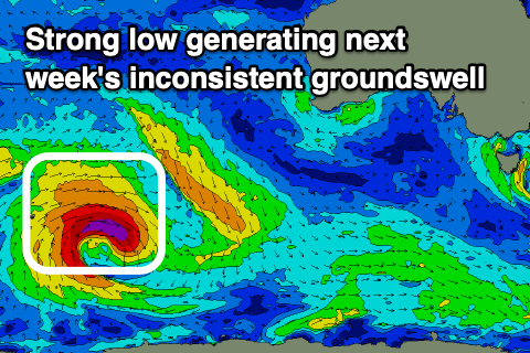
The first mix of W/SW and S/SW swells filling in Tuesday will be generated by a strong polar low forming just east of the Heard Island Friday morning.
It'll project a good fetch of gale to severe-gale W/NW winds through our far swell window, before tracking along the polar shelf, under the country in a much weaker form. The initial stages will generate an inconsistent W/SW groundswell, with mid-period S/SW swell from the later stages.
The swells should build through Tuesday, reaching an inconsistent 2-3ft into the afternoon on the Mornington Peninsula, small to tiny on the Surf Coast, with Wednesday seeing a touch more size to 3-4ft and 2ft respectively.
Conditions look great with an offshore N/NE breeze Wednesday, possibly variable into the afternoon and then all day NE winds on Thursday with a slight drop back in size, smaller again Friday.
Longer term a burst of stronger polar frontal activity south-west of WA is on the cards through the middle to end of next week, generating some better swell next weekend, but we'll keep an eye on this and provide an update Friday.


Comments
Off topic but how is the wind doing this?
What ya mean, it's mostly variable over Orbost way? Is that the location. Check the wind strengths along with direction.
Gotcha, Mallacoota and Therdbo are 15knot NE and the opposing are just light variable.
Shoulda done a bit more groundwork before getting excited!
Roger.
What about this one. Hopefully other people have thought about this: -
When it’s solid and glassy, a set comes and if your out the back for it where its just about to break, you duckdive and when you come up it’s like a onshore breeze after you pop up, clearly visible on the surface. It’ll noticeable mostly on the first and second waves as you get under them before they break.
Thoughts? Some more anecdotal evidence?
Yep, have experienced that, and also when offshore, the wind blowing up harder up the face as you paddle over.
It's all because of the displacement/squeezing of air.
So when glassy, ie no wind, the waves moving towards you lifts into the air, squeezing and shifting the air mass slightly up and towards you so then on the backside as it passes, the air filling in behind comes in, filling the low pressure void.
Not the best explanation but it's like a bus pushing past you on the street, in its wake there's the rush of air behind it filling the low pressure void.
When it’s solid and I have to duck dive a big set I’m not usually thinking about minuscule wind variations, sorry Nick.
Ha.
Perfect. The bus analogy sums it up nicely.
Or a strong offshore big day in SW WA where the wave goes past and you are blinded by the spray, then it falls on you like little droplets and you shiver and wish you had a slightly thicker wetsuit. Paddling into the next one you are completely blind until half way through the bottom turn, and take the drop in braille.
Happens here too. 30 knot Northerly and solid swell and you can’t even breathe after.