Options across most locations this week
Victoria Forecast by Craig Brokensha (issued Monday 30th December)
Best Days: Early-mid afternoon today, Surf Coast Wednesday morning, Thursday morning, Friday selected beaches
Recap
Good, fun waves on the exposed beaches Saturday morning ahead of a change through the late morning/afternoon depending on location, poor yesterday with smaller surf and lingering onshore winds.
Today is nice and clean across all locations but we've got a low point in swell. A new W/SW groundswell due to build through the day has yet to hit the Cape Sorell wave buoy and with a travel time of a few hours, the afternoon will be the one to target for a surf. Winds are expected to strengthen from the N'th, shifting N/NW on the Surf Coast mid-afternoon and then W/SW-SW across all locations late afternoon/evening. So time your surf smartly.
This week and weekend (Dec 31 – Jan 4)
This afternoon's increase in W/SW groundswell which is expected to reach 3ft+ by late today on the Surf Coast magnets and 5-6ft on the Mornington Peninsula will start easing into tomorrow (3ft sets Surf Coast, 4-5ft to the east) and conditions will be average to poor with a moderate to fresh SW'ly in the wake of a cool change this evening.
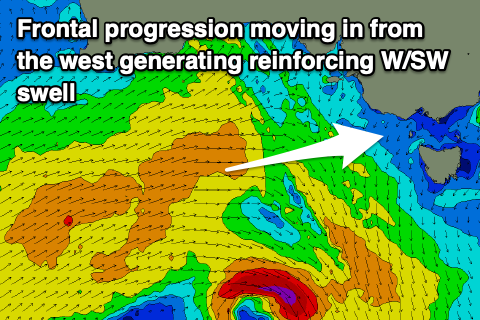
The frontal system linked to this change is generating a broad fetch of strong W/SW winds through our western swell window, with a weaker but slightly bigger mid-period W/SW swell due to possibly show later tomorrow but peak through Wednesday across the state.
3-4ft sets are due on the Surf Coast swell magnets, smaller in more protected spots and to 5-6ft on the Mornington Peninsula.
 Conditions are looking much better with a morning W/NW breeze on the Surf Coast, shifting giving into SE sea breezes on the Surf Coast, more S-S/SW to the east.
Thursday's winds look similar, though the Mornington Peninsula may see more variable breezes early. The swell will be a touch smaller though, steadying in size, owing to a weak front moving under WA and through the Bight tomorrow, producing a reinforcing mid-period W/SW swell.
Sets to 3ft are due on the Surf Coast swell magnets most of the day, easing from 2ft to possibly 3ft Friday morning, 4-5ft on the sets across the Mornington Peninsula Thursday, easing from 3-4ft+ Friday morning.
Winds will swing around to the east on Friday, favouring selected spots east of Melbourne, and mostly poor to the west.
The swell is due to bottom out on Saturday morning and besides a possible dawn N'ly, a fresh W/SW change will move through creating poor conditions.
 No major swell is due from this change, and our models are incorrectly combining a long-period and distant W/SW groundswell generated in the southern Indian Ocean on the weekend with some localised mid-period/windswelly W/SW energy.
Conditions will be poor in any case with a fresh onshore S/SE breeze, persisting Monday as the swell fades.
Longer term some new swell is on the cards for late next week, but more on this Wednesday. Have a happy and safe New Year!


Comments
Finally..
Ahh, I was just about to post that exact image Craig, maybe late arvo just before the change....
Hey Craig, still in SA on the South Coast. Have been keeping a close eye on the CDC and CS buoys. Out of interest, for say a standard SW swell, is there much of a time lag between it hitting SA and making it to Vicco? Vicco further S but I guess it would usually hit SA first.
This morning there were nice long period lines W of VH but pretty straight. Had some push behind it.
Yeah I've had the same on long period groundswells so straight for the beaches and a waste.
Oh and timing wise, the more west in the swell the more difference from Vicco and the more south, the more it hits Sorell first, somewhere in between they hit flush. Just draw a line between them, get a perpendicular to that and that's the direction, about SW.
Check this guys story.. :o https://www.instagram.com/cainecherubin/ If ya know ya know so no need to name but wow.
Some little runners now but that NW wind is not helping at 13th
Current max temps:
Geelong - 43.6°C
Aireys Inlet - 41.8°C
Cape Otway - 40.8°C
Wilsons Promontory - 40.0°C
Port Fairy - 39.9°C
Cape Nelson - 39.5°C
Inland must be brutal.
Out in the water, about 4pm this smell of dirt came through as the clouds built up. Kind of like mouldy wet dirt. Why does that happen? Moisture evaporated from inland?
Ah i've had that, dust storms mixed with the rain from the storms..