Lots of surf days to pick from this period
Victoria Forecast by Craig Brokensha (issued Wednesday 13th November)
Best Days: Protected spots Thursday, Friday, Saturday morning, early Sunday, Monday
Recap
Poor conditions at dawn yesterday on the Surf Coast, but improving quickly as winds backed off and swung to the west and a strong new SW groundswell filled in. The surf kicked to 4-5ft+ with 8ft waves on the Mornington Peninsula, best in protected spots with fresh to strong W-W/SW winds.
The swell is still large this morning and out of a more S/SW direction, pumping in protected spots on the Surf Coast and only for experienced surfers. The strongest of the swell is being seen today, though there are lots of fun surf days ahead.
This week and weekend (Nov 14 - 17)
The coming days are looking really fun in protected spots on the Surf Coast with moderate levels of swell and persistent westerly winds.
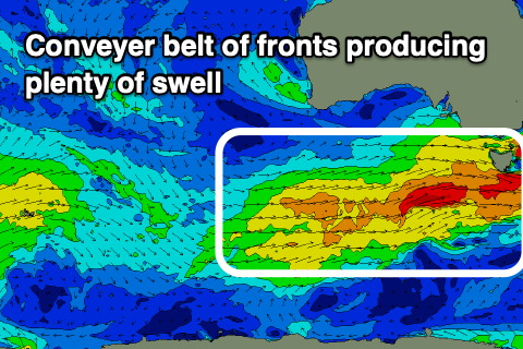
The strong low linked to our strong SW tending S/SW groundswell yesterday and today has moved east across Tassie and out of our swell window, but we've got back to back fronts on the way, generating reinforcing pulses of mid-period swell.
 The first is currently approaching from the south-west and we'll see it generate a mid-period SW swell for tomorrow, with the Surf Coast due to come in at 3-4ft, easing slightly into the afternoon with 6ft sets on the Mornington Peninsula.
Behind this a strengthening mid-latitude front will generate strong pre-frontal W/NW winds in our swell window tomorrow, with a trailing tight fetch of embedded gales.
Then behind this a more drawn out fetch of strong W/SW winds will be slow moving through our swell window Friday and Saturday.
Ebbs and pulses of mid-period W/SW tending SW swell are due from these sources, with a low point in size likely Friday morning, though not below 3ft+ on the Surf Coast and 4-5ft+ to the east.
The swell should build back into the afternoon to 3-4ft on the Surf Coast, 6ft to the east and hold Saturday, easing slowly from Sunday morning.
There may be the odd sneaky bigger one at magnets from later Friday through Saturday and looking at the winds, protected spots will be best. A W/NW-NW offshore is due tomorrow morning, strengthening from the W/NW through the day, then similar Friday but shifting W/SW late afternoon.
Saturday morning should offer a W/NW offshore, but a SW change is due late morning, while Sunday looks to offer a shorter window of clean conditions, W/NW early but swinging onshore mid-late morning.
The window for cleaner conditions east of Melbourne on Monday is still on the cards, with improving conditions under a dawn N/NW tending N'ly breeze and possibly more variable N/NE into the afternoon.
Size wise we'll be looking at a further drop in swell, 2ft to maybe 3ft on the Surf Coast and 4ft to the east. We'll see a temporary drop in swell activity through the week ahead of more frontal activity later in the week, producing swell into the following weekend. More on this Friday though.


Comments
Excellent! :)
This is actually bullshit.
Monday - piss weak swell by the arvo with sea breeze. Another shit window if your working. Shouldn’t have to fucking take a day off work just to potentially get a wave.
SE in winter too make up for this? Of course not
Not happy SAM haha
Cracked a smile then, but now back to the fury
You don't need a day off mate, you need an extended holiday by the sounds of it
Haha
Just want my seasonal rights. Sea breeze too please D
How we now looking size wise for the Surf-coast tomorrow AM? in-land today and heard the swell has dropped off a bit.
Head-high range.