Poor easing surf with limited options
Victoria Forecast by Craig Brokensha (issued Wednesday 29th May)
Best Days: Keen surfers Surf Coast early Friday and early Saturday, Surf Coast Tuesday morning
Recap
Another great day of Surf Coast reef waves yesterday with the swell hanging in at 4-5ft on the magnets with favourable winds, increasing a touch later in the day but more so today with large and a little raw 6ft surf west of Melbourne. To the east it's large and stormy, best in protected spots.
We should see today's mix of W/SW and SW groundswells peaking around 6ft+ on the Surf Coast and 8-10ft on the Mornington Peninsula as winds shift W/SW.
Today’s Forecaster Notes are brought to you by Rip Curl
This week and weekend (May 30 – Jun 2)
Today's large mix of W/SW and SW groundswells will peak this afternoon and tail off slowly through the end of the week and further through the weekend.
The vigorous and broad low linked to the current swells is slowly moving east today, with a strong W/SW change due to push through early-mid afternoon.
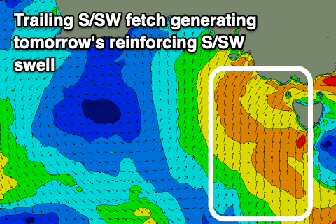
 A trailing fetch of strong to gale-force S/SW winds up through our southern swell window today will generate some mid-period S/SW swell to the mix tomorrow, similar Friday as a secondary polar front projects up and towards us.
Unfortunately winds will be poor and fresh and gusty from the S/SW tomorrow leaving limited options for a decent wave with large easing 5-6ft sets on the Surf Coast, 8ft on the sets across the Mornington Peninsula.
Friday should still be 4-5ft on the Surf Coast and 6ft+ on the Mornington Peninsula, easing through the day as fresh SW winds persist. A short period of W'ly winds is looking more likely around Torquay now, but it won't be great and only for the keen.
Easing sets from 3ft and 4ft+ respectively are due on Saturday out of the S/SW as winds remain moderate to fresh from the SW, likely W'ly early around Torquay again.
Winds will shift back to the NW on Sunday but there'll be no decent swell left, clean but tiny on the Surf Coast, bumpy and small to the east.
Next week onwards (Jun 3 onwards)
The outlook into early next week is still a little up in the air but it's generally average as a strong and deepening cold front pushes up and across us Sunday evening. A fetch of strong S/SW winds will be aimed through our southern swell window, generating a poor S/SW windswell Monday along with S/SW winds.
The swell should ease through Tuesday as winds shift back to the W/NW, with OK waves on the Surf Coast as the S/SW swell eases.
Longer term a long-range and inconsistent W/SW groundswell is likely later week but with dicey winds, more on this Friday.

