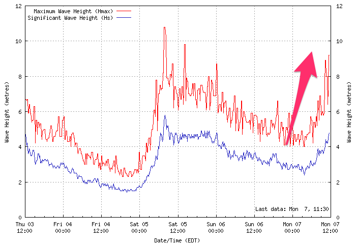
Strong SW groundswell inbound though with onshore winds
Victoria Forecast by Craig Brokensha (issued Monday 7th January)
Best Days: Tuesday morning, Thursday morning Surf COast, Friday morning exposed beaches
Recap
A small onshore start to Saturday morning, with our new moderate to large sized W/SW groundswell expected into the afternoon hitting both the Cape Sorell and Point Nepean buoys hard but observations on the coast were less than exciting. No real size was reported which is disappointing.
Sunday was much cleaner but the swell easing back from a smaller and weaker 3ft on the Surf Coast magnets, bigger though bumpy to the east.
This morning is smaller though not too bad with a weak onshore wind and 2ft to occasionally 3ft sets on the Surf Coast, lumpy and 3-4ft to the east. Our new SW groundswell is building strongly off Tasmania but this is discussed in more detail below.
Today’s Forecaster Notes are brought to you by Rip Curl
This week and weekend (Jan 8 - 13)
 The weekend's fizzer of a westerly swell will be followed by a better aligned and longer-period SW groundswell later today and tomorrow, generated by a strong and slow moving polar low.
Satellite observations (which are patchy owing to the US Government Shutdown) show a good fetch of severe-gale W/SW winds aimed through our south-west swell window, and this should have been the case since late last week through the weekend.
The low is currently passing under Tassie, and we're seeing the swell building strongly off Cape Sorell already with this swell kicking solidly later today, a little ahead of schedule and likely peaking early tomorrow morning.
Surf Coast swell magnets are still expected to come in at 3-5ft tomorrow morning with 6ft to possibly 8ft sets on the Mornington Peninsula, easing through the day.
Winds aren't great but should be workable with a light to moderate S'ly breeze through the morning, freshening from the S/SW through the day.
Wednesday morning will be smaller and back to the 3ft range on the Surf Coast and conditions look average with a fresh and gusty SW'ly breeze.
Into the afternoon a small mid-period W/SW swell is due to fill in, generated by a weak frontal system projecting towards us today and tomorrow. Wind strengths will only be strong and as a result we should see the Surf Coast persisting around 3ft on the sets into Wednesday afternoon, with 4-5ft waves on the Mornington Peninsula, easing back from a similar size Thursday morning.
Conditions will become cleaner Thursday morning around Torquay with a morning W/NW breeze expected, SW at all other locations.
Friday will be a day for the exposed beaches to the east with smaller easing 2ft sets on the Surf Coast, 3-4ft on the Mornington Peninsula and with an E/NE-NE morning breeze.
The weekend isn't looking too special with the swell bottoming out on Saturday with average W/SW tending S/SW winds, while there may be a small pulse of windswell for Sunday though with SE winds.
We may see a slightly better W/SW groundswell early next week, but the storm generating this will be dipping unfavourably through our western swell window. Winds also look to be an issue with back to back highs moving through broken up by weak trough lines. This generally results in S to E winds,but more on this Wednesday.


Comments
Worst summer for southerlies in 5 years I reckon. Has kept the weather nice and cool at least
Now that was a fun morning, sure it was a bit fat with the higher tide but a solid ground swell in the 4-5ft range lining up through the bowl and not too many around in the middle of summer.......magic!
Great to hear this swell came in on forecast.
Yeh Craig, you guys have it pretty much dialed in, care to share what resource you use to track polar lows? The GFS and G models I utalise unfortunately don't cover a vast enough area to capture our entire swell window so I missed the low skirting polar shelf.
Our WAMs capture them great.. https://www.swellnet.com/reports/australia/victoria/torquay/wams
Here it was in Friday's notes..
Yeh Craig, I read it in your forecast notes but couldn't see the system on my usual charts. I use your WAM's a fair bit too but I like to cross reference all the available weather resources in an attempt to learn the art of forecasting myself. BOM has a polar chart but it's pretty hard to read/work out the direction, fetch etc of the swell that's being generated in regards to land masses.
Gary was pleasantly surprised with the amount of pumping this morning.
Even from the carpark, Gary could see how thick and firm it was as it rolled over the button
Fark haha.
Happy New Year GG.
Thanks Craig,
Hope your 2019 is filled with plenty of double Gary sessions.