Options on both coasts this week
Victoria Forecast by Craig Brokensha (issued Monday 10th December)
Best Days: Exposed beaches Wednesday, Surf Coast Thursday morning
Recap
A small new pulse of inconsistent W/SW swell Saturday morning with workable variable winds across both coasts, freshening from the S/SW into the afternoon.
Yesterday was poor as winds remained onshore along with no decent swell.
Today a better W/SW groundswell has filled in offering 3ft sets on the Surf Coast and 5-6ft waves to the east, but with onshore winds again.
Today’s Forecaster Notes are brought to you by Rip Curl
This week and weekend (Nov 11 - 16)
Today's swell will ease off through tomorrow, slowed slightly by a small reinforcing W/SW pulse generated by weak front passing under WA over the weekend.
Surf Coast swell magnets are due to ease from 2-3ft, with 4-5ft sets to the east, but a moderate south-east wind will continue to create average conditions, freshening into the afternoon.
Wednesday is looking cleaner on the beaches with an E/NE tending NE breeze through the morning, possibly holding through the entire afternoon. Size wise, the Surf Coast will be small and fading from 2ft on the sets, with better 3-4ft sets on the Mornington Peninsula.
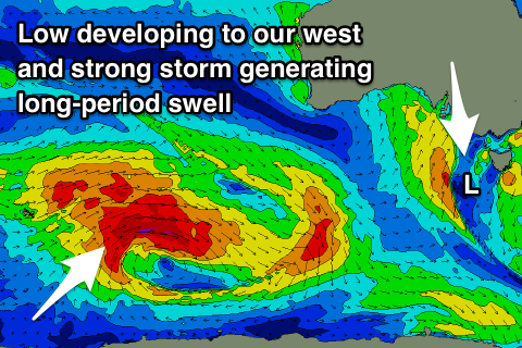
 Later in the day and more so Thursday a new W/SW groundswell is due to fill in, generated by a distant fetch of W'ly gales (even a touch stronger core winds) between Heard Island and WA through the weekend. The storm is currently weakening south of WA, with an increase in size likely Wednesday afternoon to 2ft+ on the Surf Coast and 4ft+ to the east, with a peak Thursday to an inconsistent 3ft and 4-5ft respectively.
Winds are a little dicey with a deepening surface trough/low to our west-southwest due to direct W/NW tending SW winds into us. This will favour the Surf Coast and create poor conditions to the east, while the low will move north-east into Friday, bringing poor and strengthening S/SE winds and a stormy increase in windswell.
The low is expected to stall across inland NSW, large in scope and encompassing the entire south-east corner of the country, weakening slowly into the weekend.
With this winds will remain onshore from the SE but weaken into Saturday with easing levels of windswell, with a return to W/NW winds Sunday along with a new long-period and very inconsistent W/SW groundswell.
The source of this swell will be a strong polar low in our far swell window around the Heard Island region, with a slow increase towards 2-3ft due on the Surf Coast Sunday, 4-5ft to the east, with a peak due Monday to 3-4ft and 5-6ft+ respectively. Winds look onshore again Monday, but more on this Wednesday.

