Improving prospects from late week with large swells to follow
Victoria Forecast by Craig Brokensha (issued Wednesday 28th November)
Best Days: Friday morning surf coast, exposed beaches Saturday morning and possibly into the afternoon, Surf Coast Monday morning - though tricky, Tuesday morning Surf Coast
Recap
About as bad as it gets surf wise across the state with no groundswell and onshore winds yesterday and today. We've got one more day to come with similar conditions as well.
Today’s Forecaster Notes are brought to you by Rip Curl
This week and weekend (Nov 29 – Dec 2)
Tomorrow is another lay day with no new swell expected until later in the afternoon, and onshore S/SW winds will continue to create poor conditions.
From Friday we'll finally see some surfable waves across the state, but Saturday is still looking the pick at this stage.
An initial mid-period SW swell is due to kick later tomorrow and peak Friday morning, generated earlier this week but a storm east of Heard Island, dipping south-east towards the polar shelf under WA.
This should provide a bump in swell to 2ft+ across most breaks on the Surf Coast (3ft sets at 13th Beach), with 3-4ft+ sets to the east.
Winds will be good for the Surf Coast and light from the W/NW through the morning, tending SW later morning and freshening into the afternoon.
Into the afternoon our slightly better and bigger W/SW groundswell is expected to fill in, holding into Saturday morning before starting to ease into the afternoon.
 This is being generated by a slightly stronger storm in our western swell window, south-west of WA, with a fetch of elongated W/SW gales currently being aimed towards us.
The elongated nature will see the swell event lasting a little longer, but size wise we should see the Surf Coast kick to 3ft or so later in the day Friday, 4-5ft to the east ahead of a peak to 3ft+ (4ft sets 13th Beach) and 4-6ft respectively Saturday morning.
Winds will be great for the beaches on Saturday morning and offshore from the N/NE, tending more N/NW on the Surf Coast late morning and to the east, early afternoon. What happens late afternoon and into the evening is still undecided by the models, we may see the onshore change delayed, so we'll have to confirm the finer details on Friday.
In any case the morning is looking super fun on the exposed beaches.
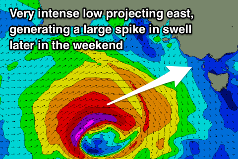
Sunday morning will start smaller and windy with a vigorous low due to encroach on us under the influence of a strong node of the Long Wave Trough across the Bight, bringing fresh and gusty W/SW winds, likely W/NW early on the Surf Coast.
A large new long-period W/SW groundswell will be produce by this low, with it developing south-west of WA and projecting a fetch of severe-gale to possibly storm-force W/SW winds through our western swell window through the end of the week.
The groundswell is expected to arrive Sunday afternoon and kick strongly late, likely to 4-6ft on the Surf Coast by dark and 8ft+ to the east but with that W/SW breeze.
The swell is due to ease into Monday morning, but a secondary frontal system will project up and into us through the day, generating a new large SW swell for the afternoon, easing through Tuesday.
With this front winds are forecast to tip back to the NW on Monday morning, but be strong to gale-force, swinging W/SW through the middle of the day. This will create tricky surfing conditions even in protected spots on the Surf Coast.
Tuesday looks better with a morning W/NW breeze and moderate to large easing south-west swell, but more on this dynamic frontal progression on Friday.


Comments
What's that rolling in through the ocean.. is it swell?
End of a drought.
Last few days there have been micro waves at unusual spots and places, it's like living on a different coast. You can have a bit of fun searching through the nothingness.