Poor week, much much better into the weekend
Victoria Forecast by Craig Brokensha (issued Monday 26th November)
Best Days: Surf Coast keen surfers Friday morning, beaches Saturday, Surf Coast Sunday morning and Monday morning
Recap
A continuation of poor stormy and easing swell on Saturday with only a couple of options for a grovel, a touch cleaner Sunday with weaker onshore winds though smaller surf again.
This morning we've got small bumpy waves across all locations again, only for desperate surfers.
Today’s Forecaster Notes are brought to you by Rip Curl
This week and weekend (Nov 27 – Dec 2)
The coming few days will remain poor for surfing with no decent size and persistent onshore winds, but we've now got a window of opportunity late week.
A moderate SE wind will create average conditions again tomorrow, freshening into the afternoon along with a small 1ft to maybe 2ft wave on the Surf Coast and 2ft to maybe 3ft wave on the Mornington Peninsula, easing through the day.
We're then looking at tiny surf across all locations Wednesday and Thursday along with S'ly tending SE winds on the former and S'ly winds on the later as a weak ridge of high pressure sits across the state through most of the week.
Into Friday we'll finally see winds start to improve, along with some good building new mid-period W/SW swell.
 Firstly a weak polar frontal progression dipping south-east from the Indian Ocean will generate a small SW swell pulse for Thursday afternoon and more so Friday morning, coming in around 2ft+ on the Surf Coast (3ft sets 13th Beach) and 3-4ft+ to the east.
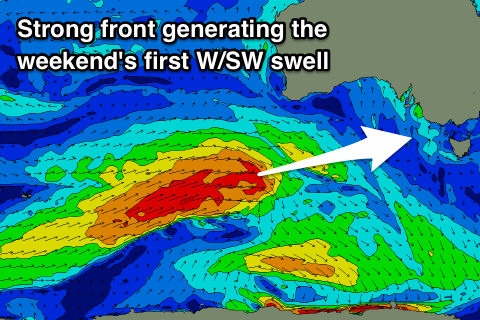
Into the afternoon and more so Saturday though we'll see a better pulse of W/SW swell, generated by a longer-lived and stronger frontal system developing east of Heard Island producing a great fetch of W/SW gales while projecting east towards us tomorrow and Wednesday, weakening into the evening.
This swell should come in at a better 3ft+ on the Surf Coast (4ft sets 13th Beach) and 4-6ft to the east.
Winds will tend light W/NW across the Surf Coast Friday morning, tending SW later morning, but Saturday looks great all day with a fresh N/NE tending N'ly breeze as a vigorous cold front pushes in from the west. This will favour the beaches all day, while bringing W/SW winds on Sunday as the swell eases.
There'll also be some new long-period W/SW groundswell from the vigorous front arriving later in the day Sunday and for Monday morning, with an even larger SW groundswell on the cards produced by a stronger follow up polar front.
This action will be linked to a strong and pronounced node of the Long Wave Trough moving in through the Bight mid-late this week, but more on this Wednesday.


Comments
Ahhhh my favourite 3 words have reappeared
Strong, vigorous pushes?
Even larger swell[ing]
Just like your one handed push ups Garry G . I’m sure they are a thing of beauty.
That's good cos it's getting really boring at present