Strong large swells inbound with favourable winds
Victoria Forecast by Craig Brokensha (issued Friday 2nd November)
Best Days: Surf Coast Saturday morning, Surf Coast Sunday, windows at locations to the east, both regions Monday morning and Tuesday morning, Surf Coast early Wednesday
Recap
Light winds early yesterday with the swell dropping back a touch from Wednesday but the beaches really lined up and started to fire with the dropping tide and freshening offshore wind, remaining clean until late arvo (13th Beach below) before a change moved through.

This morning we've got a bit of size left across the beaches with clean sets to 3-4ft, but winds quickly shifted more N/NW and the Surf Coast was mostly 2ft, with good 3ft sets at 13th Beach and other magnets.
Winds will swing more west through this afternoon as the swell continues to ease.
Today’s Forecaster Notes are brought to you by Rip Curl
This weekend and next week (Nov 3 – 9)
We've got a very active forecast period ahead owing to a strong node of the Long Wave Trough developing across the Bight and moving slowly east through the weekend and next week.
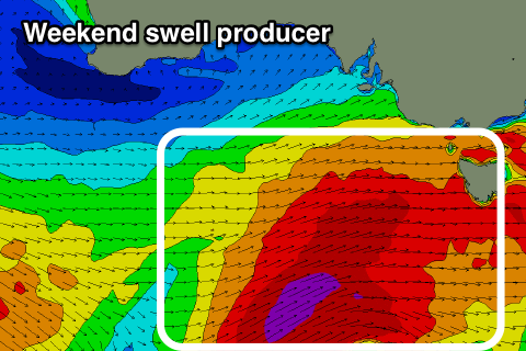
Currently a vigorous cold front is passing under WA and through the Bight, generating a fetch of W/SW gales in our western swell window.
 During today we'll see this storm broaden and strengthen while on approach from the west, with a great fetch of W/SW gales projected through our western and south-western swell windows, with the front moving through proper later this afternoon/evening.
With this we'll see a moderate to large W/SW groundswell that will build and strengthen through tomorrow, likely coming in at 3-4ft on the Surf Coast early tomorrow morning, but building quickly to 5-6ft on the sets into the afternoon.
At the core of this storm winds look a touch weaker than suggested Wednesday, with a great fetch of severe-gale SW winds projected on top an active sea state through our southern swell window this afternoon through tomorrow morning.
This will generate a larger long-period S/SW groundswell for Sunday morning coming in at 6ft+ across the Surf Coast, with 8ft to possibly 10ft sets on the Mornington Peninsula, easing through the day.
Looking at the local winds and a gusty W/SW breeze is due most of tomorrow, W/NW through the morning on the Surf Coast, while Sunday looks excellent with a moderate NW-N/NW offshore across both regions, tending variable ahead of mid-afternoon sea breezes. There's a chance winds will go N/NE for a couple of hours on the Mornington Peninsula, but in any case the spots handling the size should be fun through the morning.
Come Monday morning we'll be seeing smaller though fun 3-4ft waves on the Surf Coast swell magnets, 5-6ft to the east with an early N/NE tending N/NW and then NW-W/NW breeze with an approaching front.
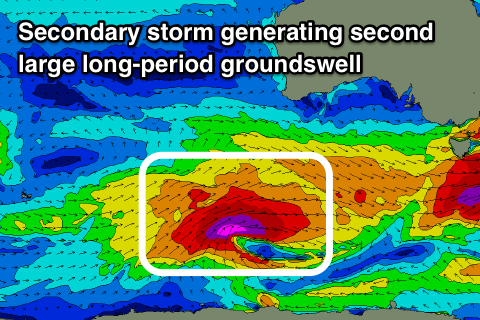
 This front will be linked to a secondary vigorous polar storm being steered up towards us under the influence of the Long Wave Trough.
The storm will develop south-west of WA tomorrow morning, with a great fetch of severe-gal to storm-force W/SW winds projected through our south-western swell window before the storm stalls and weakens south-west of us Sunday evening.
As it stalls a secondary weaker front will spawn off its tail and push north through the Bight Monday and then across towards us Tuesday, with an afternoon change.
This will be fairly ideal as we'll see the large long-period SW groundswell fill in Tuesday, peaking through the morning to 4-6ft on the Surf Coast and 8ft on the Mornington Peninsula with a morning N/NW breeze, giving into an afternoon W/SW change.
With the weak nature of the front no significant swell is expected in its wake, with easing surf with W/SW winds Wednesday (W/NW early on the Surf Coast).
We'll see the swell continue to ease into the end of the week with winds from the western quadrant, but we'll have a closer look at this Friday. Have a great weekend!


Comments
Of all the weekends to go camping at a coast with no waves... nooooooi
The Prom?
Bemm river
Ouch.
There’s waves there goofy. Hard to get to / find and need lucky swells. The bream and perch fishing seriously makes up for it!!
Couple of fish and a few beers will do just fine!
Feeling ya pain a bit goofyfoot, normally jumping out my skin to go indo but this time round feeling like I should have stayed home
I’ll happily trade places with ya
Current forecasted swell direction is wsw for the Torquay region, which generally results in burgers pushing wide down the main reefs, and a fair portion of the energy moving past. This fact seems to be lost on a particular surf forecaster (not you Craig) from another website that continually misses the mark on the resulting size and quality of this swell direction and yet talks it up with calls of 'epic' and recommends everyone jumps on a farking plane. What an idiot.
They're fucking useless over there.
Yeh saw that hoe pokey. But he apologized in advance.
The only thing the suggested 8ft gun would be useful for is out paddling the 150 punters out at Bells waiting for the inconsistent fat 5 footer
Can everyone please just fuck off to Flemington for Derby day..........and stay for the cup on Tuesday
Being locked out of the forecast notes for now, and not bothering to look at certain other sites, all I'm hearing is the grapevine locally. OK something is coming. It should be given all the thunderstorms, heat, humidity and incredible coloured skies in the morning. Are people really suggesting 8 foot guns? Will we get the same event as in the winter, everyone heads down to be there, swell is large, everyone ends up surfing waist to chest high waves at certain protected spots? Only the weekend will reveal the truth...
No mention of 8ft guns here.
There will not be a wave over 6ft on the Surf Coast this weekend, unless it's a fat burger at Bells, which doesn't even count.
8ft sets easy.
Look at the maps.
STFU The Plowking.
Why don't you just send out a hand written invite to every Melbourne punter who's rubbed wax on a board?
You're a muppet.
Farking lol.
It's a bloody long weekend.
Is this some kind of magic ink forecast website secret society? Forecast notes disappear on reading, remain secret?
The majority won't surf it at that size.
Get over it.
I'll be busy surfing.
Don't worry about Vic Local, hes just stressing that he won't get a car park at Pt Roadknight.
<script async src="//s.imgur.com/min/embed.js" charset="utf-8"></script>
="imgur-embed-pub" lang="en" data-id="a/F4HZzo5">
<script async src="//s.imgur.com/min/embed.js" charset="utf-8"></script>
https://imgur.com/a/yo0s3tJ
Funny old day today, 4ft and washing wide of the bowl due to the wsw in the swell, some bigger sets starting to come through in the 5ft to maybe 6ft range, Winki looked fun but there was a hectic sweep and over frothing crew as per normal. Still, nice to see some size and power again. Get out there!
Of all anecdotal reports. I like the WAG.
impressive numbers on the pt nepean buoy as well (sig height and period of 3.94m and 13.5s)
Far out it is solid.
Pumping.
What a day!
Looked to be some sets nudging 8ft at the magnets mid-morning. Some bloke had a shocking run over the button. Had to duck a heap of waves in ankle deep water. Paddled our just as a 10-12 wave set started feathering at Centreside.
What a day!! Pumping everywhere and still on as I dig into baked goods after my second surf for the day. Recharging for the late!!
Craig when you get a chance after the baked goods or the late, do you reckon you could post a pic of the fetch that generated this? It was unrelenting.
Check below VJ.
On the 16th the forecast is predicting a 6ft easterly how do the reports predict it if easterly swells are so close range and form and go so quickly
Maybe let’s just wait until this out of season run of quality groundswell is over before worrying about 6ft of south-easterly storm swel :p
VJ here's what generated the weekend's swell event, strengthening and broadening W/SW fetch and then it stalled with core winds to 45kt projected through Vicco's southern swell window on top an active sea state.