Strengthening swells, likely large late next week
Victoria Forecast by Craig Brokensha (issued Wednesday 26th September)
Best Days: Surf Coast Saturday morning, Sunday, all locations Monday and beaches Tuesday, Wednesday Surf Coast
Recap
A continuation of poor surfing conditions yesterday with a drop in swell from Monday, while today a new S/SW groundswell has kept the Surf Coast up around 3ft, while the direction unfortunately looks to be too south to really impact east of Melbourne with slow 3-4ft sets.
Conditions were better but still average with E'ly winds, though these will tend more E/NE through the morning ahead of sea breezes as the swell eases.
Today’s Forecaster Notes are brought to you by Rip Curl
This week and weekend (Sep 27 - 30)
This morning's pulse of S/SW groundswell will ease off through this afternoon and further tomorrow leaving small fading waves across all locations.
Surf Coast swell magnets should see 2ft sets early tomorrow, tiny into the afternoon with infrequent easing sets from 3ft on the Mornington Peninsula.
 Conditions will be clean on the beaches early with a N'ly breeze, while an approaching front will swing winds more NW during morning and then W/NW into the afternoon.
All in all tomorrow isn't looking great with the small fading swell.
Friday morning will start small to tiny with a W/NW breeze, but our new W/SW swell for Saturday has been upgraded, with a good increase in size due Friday later afternoon but with a W/SW change.
The weak front that's due to push in from the west today and tomorrow has been upgraded a little in strength, with a broad and good fetch of strong to near gale-force W/SW winds being projected through our western and then south-western swell window.
We should see windswelly waves building Friday afternoon and reaching 2-3ft at swell magnets on the Surf Coast by dark, 4-5ft to the east, while a peak in mid-period swell is expected Saturday.
The Surf Coast should see surf to a consistent 3ft, with the odd bigger one more than likely at swell magnets through the day, with 4-5ft+ waves to the east.
Winds are generally expected to be from the W/SW-SW through Saturday, but the Torquay region should see a morning W/NW breeze, favouring the protected reefs.
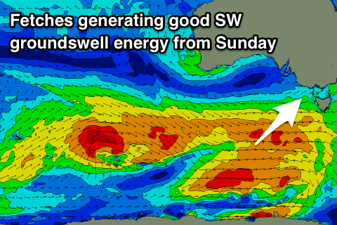
Our stronger pulses of groundswell from Sunday through next week are still on track, with an elongated fetch of W/NW gales pushing in from the Heard Island region over the coming days, broadening through tomorrow south of WA and then pushing a bit further north towards us into Friday.
 This should generate a moderate to large SW groundswell that's expected to build Sunday, peaking Monday morning with a reinforcing pulse for the afternoon generating by another significant pre-frontal W/NW fetch.
Size wise the Surf Coast should build to 3-4ft Sunday afternoon with 5-6ft waves to the east, with Monday seeing 4ft+ and 6ft+ sets respectively.
Winds will be great for the Surf Coast Sunday morning and out of the W/NW, lighter SW into the afternoon and then Monday looks great across all locations with a morning N'ly, with a shallow change possible into the afternoon. We'll have to review this Friday.
A mid-latitude low moving in slowly from the west may keep winds offshore from the N'th as the swell eases Tuesday but then later in the week we're looking at a larger long-period SW groundswell as a severe low forms south of WA, projecting a significant fetch of severe-gale to storm-force winds towards us, but more on this Friday.

