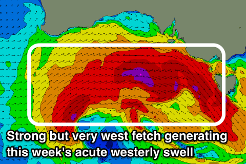
West, west, west
Victoria Forecast by Craig Brokensha (issued Monday 14th August)
Best Days: Surf Coast tomorrow, locations to the east later in the day, Surf Coast later Wednesday, Thursday and Friday morning
Recap
Persistent westerly swell energy over the weekend, cleanest on the Surf Coast and hovering around 2-3ft, with bigger messier conditions to the east.
Today a mix of new W/SW and SW swells have come in a bit above expectations with good but raw waves in the 4ft range on the Surf Coast magnets, while the beaches to the east were only reported to be 4-6ft.
Today’s Forecaster Notes are brought to you by Rip Curl
This week and weekend (Aug 15 - 19)
Today's spike in new W/SW and SW swells should ease back into tomorrow, steadied by a new mid-period W/SW swell.
This swell is being generated by a broad but less than favourably aligned fetch of strong to gale-force W/NW winds that moved in south of the Bight, and are currently south-west of us.
The Surf Coast swell magnets should hang in at 3ft on the sets with 4-6ft waves to the east under an improving NW tending N/NW breeze.
 We should see a temporary low point in swell early Wednesday to 2ft to occasionally 3ft on the Surf Coast and 4-5ft to the east but some new mid-period W/SW swell and then groundswell are due to build into the afternoon, peaking Thursday morning.
These swells will be generated by a strong mid-latitude frontal system forming south-west of WA this evening, deepening while pushing east through the Bight.
The system is looking a little more consolidated in its early stages compared to last week's forecasts, but will sit fairly far north and on the edge of our western swell window.
A strong fetch of severe-gale to near storm-force W'ly winds will be projected east, with the low starting to break up while remaining strong on Wednesday as it passes across us.
We'll see a severe-gale W/NW fetch generated right on our doorstep early Wednesday morning followed by a rapidly weakening post-frontal W/SW fetch into the afternoon.
We should see the surf starting to build through Wednesday owing to the pre-frontal W/NW fetch, likely reaching 3ft+ late on the Surf Coast and 6ft to the east along with strong and persistent W/NW winds.
The groundswell is expected to peak Thursday morning, but under the model forecasts with Wave Watch incorrectly combining a multitude of westerly swells.
The Surf Coast looks to ease back from the 4ft range at magnets (much smaller in protected spots) and 6ft+ to the east as winds hold out of the W/NW for most of the day, again favouring protected spots.
The swell will continue to fade into Friday from 2ft to maybe 3ft on the Surf Coast and 4-5ft to the east with NW offshore winds.
As we move into the weekend there's nothing too major on the cards with weak unconsolidated mid-latitude frontal activity keeping small surf hitting the not so aptly named Surf Coast.
A strengthening polar front is forecast to move into us Sunday but with developing strong to gale-force S/SW winds late in our swell window, only a weak windswell turning mid-period S/SW swell is due to build Sunday with poor W/SW tending SW winds.
Into next week the swell is expected to ease through Monday with nothing too significant through the rest of the week with favourable NW winds, but we'll have a closer look at this on Wednesday.


Comments
This is pretty fucked. I thought the SAM at quick glance fluctuated like a tide like a up and down roller coaster. But after actually having a look it seems the negative is stronger and more frequent as opposed too the infrequent and weak positive.
I thought we were on a upward tread but the forecast for that looks grim as fuck.
Fuck..
You can see the AAO/SAM forecast here, at the start of the month it had it staying negative until mid-month.
http://www.cpc.ncep.noaa.gov/products/precip/CWlink/daily_ao_index/aao/new.aao_index_ensm.html
Ahhh Nick, I feel your pain matey, I lived in Rye many moons ago and would watch closeout's and westerly quadrant winds all winter long, knowing that just across the other side of Port Phillip bay it would be pumping under the same scenario. Its all relative though, come summer, I'll be the one who is again forced to drive long distances for proper waves that handle the summer wind and I will be calling your preferred swell and wind combo the devil. Jump on the ferry and wash off some of that pent up tension!
I'd say very aptly named surf coast. (In winter)
Still some nice lines in Torquay with golden light for the arvo session.

Jeez you’re an optimistic bastard
At least it wasnt a pic of lorne point. And FYI, its called golden hour.
Golden light is seen during golden hour, no?
Don't even start Gary G on golden showers.
I had Gary G pegged as a bubbler type bloke.
I really don't know what that is and happy to stay that way, lol.