Fun tomorrow, followed by a swell upgrade
Victoria Forecast by Craig Brokensha (issued Wednesday 1st August)
Best Days: Exposed coasts Thursday, exposed spots Saturday afternoon, Sunday through early-mid next week on the Surf Coast
Recap
Monday's spike in close-range swell eased back as quickly as it came, leaving less consistent levels of long-range W/SW groundswell across the Surf Coast mostly to 2ft, with stray 3ft sets hanging in at 13th Beach. Gusty N/NW winds swung more NW through the day and then strong W/NW into the afternoon with no new increase in swell.
Today we've got a mix of new mid-period W/SW swell and stronger W/SW groundswell on the build with good winds for protected locations on the Surf Coast. The surf was in the 3ft to occasionally 4ft range across magnets, but we should see the groundswell peaking this afternoon in that more consistent 4ft range as winds tend variable.
To the east we should see sets pushing to 6ft+ with a slight improvement in conditions as the westerly breeze eases.
Today’s Forecaster Notes are brought to you by Rip Curl
This week and weekend (Aug 2 - 5)
Want to receive an email when these Forecaster Notes are updated? Then log in here and update your preferences.
Today's mix of W/SW swells are due to start easing through tomorrow after a peak this afternoon.
We'll also see winds become unfavourable for the Torquay reefs but great for the exposed beaches and fresh and gusty from the N/NE.
The Surf Coast will see easing sets from the 3ft range with 4-5ft sets on the Mornington Peninsula.
A low point in swell is due Friday morning with small to tiny leftovers on the Surf Coast and 2ft to maybe 3ft sets to the east under a gusty N'ly wind. A shift in winds to the NW is due through the afternoon with some possible small hints of new inconsistent W/SW groundswell.
Saturday is a better chance to see this swell, but of greater importance is an upgrade in the size due through Sunday and Monday.
Currently we're seeing a flurry of strong mid-latitude frontal activity in the south-east Indian Ocean, pushing up and over WA through our far western swell window.
Tricky and not overly strong fetches of W/SW winds are being directed towards us, producing small levels of W/SW groundswell that should be seen late Friday but more so Saturday.
The Surf Coast swell magnets look to come in at an inconsistent 2ft on Saturday with slightly better 3-4ft sets on the Mornington Peninsula. We'll see fresh and gusty N/NW winds swinging more N'th through the day Saturday, providing improving conditions across those beaches east of Melbourne after lunch. There's a chance for some stronger sets late afternoon, but I'd keep your expectations low.
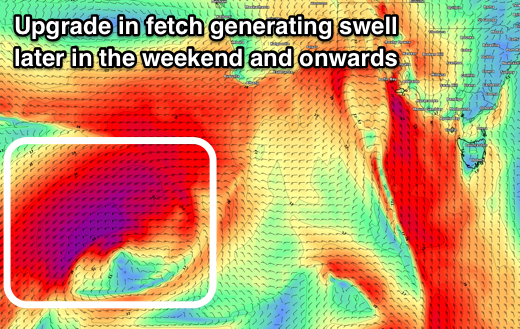
Moving into Sunday, our new pulses of better W/SW groundswell from a pre-frontal and post-frontal fetch around a strong low have been upgraded fairly significantly.
 This low is now expected to be much stronger and longer-lived, with the initial pre-frontal fetch of severe-gale W/NW winds setting up an active sea state for a storm-force fetch of W/SW gales to move over, projecting slowly through our western swell window for 24 hours, before stalling south of WA and weakening a touch.
We'll continue to see a fetch of severe-gale W/SW winds aimed through our swell window, before it slowly moves east while breaking down on Sunday.
A moderate to large sized and prolonged W/SW groundswell event will be seen, with the strongest long-period component arriving later Sunday morning and kicking strongly into the afternoon.
The morning looks only looks to be around 2-3ft or so on the Surf Coast and 4-6ft to the east, but the new long-period groundswell should kick to 4-5ft and 8ft at swell magnets respectively by dark.
We should see the swell persisting around a similar size range on Monday owing to the slow and stalling nature of the low, with a slow drop in size through Tuesday.
Winds on Sunday look to swing from a fresh and gusty morning N/NW breeze, around to the NW through the afternoon, with persistent W/NW breezes on Monday.
The outlook for the rest of the week is moving around too much to pin down at the moment, but check back here Friday for an update on the W/SW groundswell due later in the weekend and beyond.


Comments
Oh yeh! Luv this time of year in Vicco, swell after swell after swell.
Beachies looking good this morning!
