Fun tomorrow, building west swells through next week as winds go full circle
Victoria Forecast by Craig Brokensha (issued Friday 27th June)
Best Days: Both coasts Saturday, Monday Surf Coast, Wednesday Surf Coast, Thursday and Friday exposed beaches
Recap
Great waves across the Surf Coast yesterday with a new SW swell filling in through the day, providing clean 3-4ft waves on the reefs, while protected locations to the east offered the best conditions.
This morning the swell was easing but still a good 3ft+ on the Surf Coast with great winds for all locations, and clean solid 4-6ft surf to the east. Winds are due to swing more W/NW, favouring the Surf Coast.
Today’s Forecaster Notes are brought to you by Rip Curl
This weekend and next week (Jul 28 – Aug 3)
Want to receive an email when these Forecaster Notes are updated? Then log in here and update your preferences.
Through the weekend we'll see the current SW swell continuing to ease, but with great winds for exposed locations tomorrow. Local offshore breezes are still expected (N/NW Surf Coast and N/NE Mornington Peninsula and variable into the afternoon) with easing 2ft+ sets at magnets on the former, and 3-4ft beachy waves on the later.
Sunday looks like a lay day with a low point in swell and freshening W/NW breeze ahead of a late and stronger W/SW change.
The change will be linked to a strong mid-latitude low drifting in from the west, crossing us Sunday evening and projecting a slither of gale to severe-gale W/SW winds through our swell window.
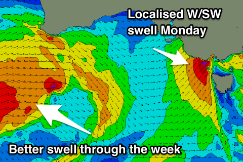
 This fetch will be short-lived and only produce a small to moderate sized spike in W/SW swell Monday morning to the 3ft range on the Surf Coast and 5-6ft to the west.
Also in the mix will be an inconsistent long-period W/SW groundswell generated by a very broad and expansive polar low that formed in the southern Indian Ocean this week.
This low has generated another XL groundswell for Indonesia and XXL W/SW groundswell for WA, but with it being in our far swell window and coming from the west, we're not expected to see anything to significant on our coasts.
The long-period forerunners are due to arrive through Sunday but with no real size (the Surf Coast may kick to 2ft+ late), with a peak due on Monday morning. The Surf Coast looks to offer infrequent 3ft sets, similar in size to the localised W/SW swell, with 5-6ft sets to the east.
Winds will be great for the Surf Coast with a moderate to fresh NW tending N/NW breeze as another strong front pushes in from the west.
We'll see some new W/SW swell energy from this mid-latitude frontal progression, produced as the storm forms south-west of WA and projects a fetch of strong to gale-force W/SW winds through the Bight before weakening while moving across us Monday evening. This will then be followed by a secondary embedded low projecting W/NW gales through our western swell window Tuesday and crossing us Tuesday evening.
We're due to see an initial increase in mid-period W/SW swell through Tuesday afternoon, followed by a solid mix of mid-period and groundswell on Wednesday.
The Surf Coast looks to build to 2ft+ later Tuesday with 4ft sets to the east under gusty W/NW tending NW winds.
Wednesday is the day to surf though with surf in the 4ft range on the Surf Coast and 6ft to possibly 8ft to the east under a morning W/NW breeze, SW into the afternoon.
We'll see the swell ease off into the end of the week as a really strong but high riding mid-latitude frontal system pushes in across the country, directing winds around to the NE Thursday and N/NE Friday.
At this stage no significant swell is due in the wake of this system as it tracks too far north, but check back Monday for more on this. Have a great weekend!


Comments
I keep looking at what SW Oz is copping (with onshores) and thinking..if that storm track was running a few thousand km further east it would have been the best Vicco winter ever....
Yep, if the Long Wave Trough was further east..
Craig, Gary would appreciate your advice.
Gary needs a new wetsuit: Should he buy an aquamarine one to highlight his piercing blue eyes, or bright orange for the contrast against the grey Victorian water.
Which would look more striking in an instagram story filmed in the Winkipop carpark?
Have to be the bright orange one, peacocking like a stimulated cuttlefish always brings the likes and followers.
Thanks ol' pal.
A bit of life advice in return: Gary would advise setting the browser to in-cog-nito before you start googling for stimulated cuttlefish
Haha, touche ;)
And there was me just worried about waves...
Good Gary.