Mix of westerly swells, better direction later week
Victoria Forecast by Craig Brokensha (issued Monday 23rd July)
Best Days: Surf Coast later tomorrow, Wednesday, Thursday both regions, beaches Friday
Recap
A large pulse of W/SW tending SW groundswell filled in Friday afternoon, easing from a pumping 6ft to occasionally 8ft across the Surf Coast on Saturday, much smaller to 3ft yesterday.
The Mornington Peninsula was best yesterday with the smaller easing swell and N'ly breeze.
The swell has bottomed out this morning with a small background W'ly swell not really offering much at all. Conditions are blustery in any case with a strong northerly breeze.
Today’s Forecaster Notes are brought to you by Rip Curl
This week and weekend (Jul 24 - 29)
Want to receive an email when these Forecaster Notes are updated? Then log in here and update your preferences.
This coming week will be filled with tricky westerly groundswell pulses and mid-period energy from a flurry of significant but northward tracking fronts.
A strong node of the Long Wave Trough stalling off the West Australian coast has been directing severe-gale to storm-force fetches up towards Indonesia and the west coast of the country, with stormy XXL surf currently breaking.
This activity was in our far swell window and not too favourably aligned, resulting in inconsistent and moderate (Surf Coast) to large (Mornington Peninsula) W/SW groundswell energy building through tomorrow afternoon and peaking Wednesday.
More consistent levels of mid-period W/SW swell are alos due in the mix, generated by the remnants of the frontal progression pushing through the Bight and dipping east-southeast across us this evening.
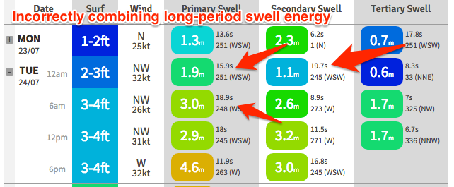
 As touched on last Friday, the Wave Watch model is incorrectly combining a few different swells and this can be seen at midnight tonight, where they're seperate and then all combined at 6am.
Realistically tomorrow looks small, with 2ft waves on the Surf Coast, likely building more to 3ft into the afternoon with gusty NW tending W/NW winds. The Mornington Peninsula will be bigger but poor with the winds.
On Wednesday we're looking at more sizey though inconsistent surf to 3-5ft across the Surf Coast and 6ft to occasionally 8ft sets on the Mornington Peninsula.
Conditions will be great again with a fresh W/NW-NW breeze, holding most of the day.
We'll see the swell starting to ease off through Thursday but this will likely be halted into the afternoon as a better aligned reinforcing SW swell fills in. This is expected to be generated on the tail of the fronts pushing across us, with a stalling fetch of W/SW gales produced in our south-western swell window.
We should see the Surf Coast become more consistent and to 3-4ft through the day, with 5-6ft waves on the Mornington Peninsula. Conditions should improve to the east with local N/NE-N winds and favourable N/NW breezes on the Surf Coast, N/NE on Friday as the swell eases.
Into the weekend there's nothing really of note with the swell continuing to drop, mixed in with some small and inconsistent levels of background W/SW groundswell. Winds will also be funky and likely onshore Saturday as a surface trough drifts across us, NW to SW on Sunday.
Another long-period but very inconsistent and small W/SW groundswell is due later Sunday and more so Monday, but we'll have another look at this Wednesday.


Comments
Are you still confident 3-5ft for tomorrow on the Surf Coast
Well the forecast is on track so far, so yeah I'd expect mostly 3-4ft surf with inconsistent 5ft'ers on the magnets. Again west swell so not ideal.