Super fun waves over the coming days
Victoria Forecast by Craig Brokensha (issued Monday 30th April)
Best Days: Both coasts Tuesday and Wednesday, east of Melbourne early Thursday, Surf Coast Friday afternoon and Saturday morning
Recap
Plenty of swell leftover into Saturday across the Victorian coast but with average onshore winds on the Surf Coast and better conditions to the east but large sets on the beaches.
Sunday was a touch smaller and onshore winds again created average conditions across all locations.
This morning we've got a strong new but inconsistent W/SW groundswell coming in around 3-5ft on the Surf Coast and 6-8ft on the Mornington Peninsula cleanest in protected locations with a light to moderate W/NW breeze.
Today’s Forecaster Notes are brought to you by Rip Curl
This week and weekend (May 1 - 6)
This morning's large and powerful though inconsistent W/SW groundswell is peaking across the region, and from here we'll see the swell drop slowly through tomorrow, further Wednesday and small into Thursday. This easing trend will be slowed by a reinforcing SW swell generated by a good broad fetch of pre-frontal W/NW winds moving through our swell window yesterday and this morning.
Conditions are set to be great across most locations the next couple of days, with local offshores tomorrow morning (N/NW Surf Coast and N/NE Mornington Peninsula), variable into the afternoon, similar but fresher and more northerly winds Wednesday.
Size wise the Surf Coast should ease back from 3-4ft tomorrow morning with large 5-6ft sets on the Mornington Peninsula. Wednesday will be better on the exposed beaches with easing 2-3ft sets on the Surf Coast and 3-5ft waves to the east.
Thursday will only be for desperate surfers with fading 1-2ft waves on the Surf Coast and 3ft sets to the east with an early N'ly, swinging NW through the day with an approaching front.
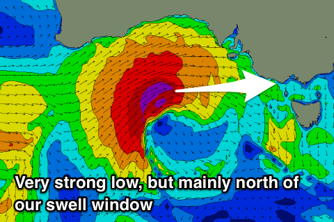
This mid-latitude front will be very intense as it pushes up under WA and through the Bight, generating winds severe-gale to storm-force W'ly winds, but these will likely be just north of our swell window.
 As the mid-latitude system approaches us Thursday afternoon and evening it's expected to start dipping back south-east more into our swell window, with a burst of weakening gale to severe-gale W'ly winds forecast.
This will produce a small to moderate sized mid-period W'ly swell for Friday, peaking through the afternoon.
Along with this we'll see fresh to strong W-NW winds, and with the westerly swell direction this won't be ideal for the Surf Coast.
We're expected to see sets building to the 3ft+ range into the afternoon across exposed spots, much smaller in protected spots that will be offshore. The Mornington Peninsula will be a mess and increasing to the 6ft range.
The swell will drop rapidly Saturday as a result of no major follow up systems and a morning NW breeze is due to swing more N/NW opening up more options into the afternoon at exposed spots. The Surf Coast is only due to ease from 2ft to maybe 3ft, with 4-5ft sets to the east.
Longer term there's some better and more persistent frontal activity due to fire up in the south-east Indian Ocean and under the country mid-late this week and weekend, bringing new swell from Sunday afternoon, but more on this Wednesday.


Comments
Super fun at Lorne this arvo. How's the lines to the horizon!

Pumping this morning and pumping on dark..
Today was a real Autumn day.
was really pulsing late morning on the reefs - some rogue sets appeared out of nowhere