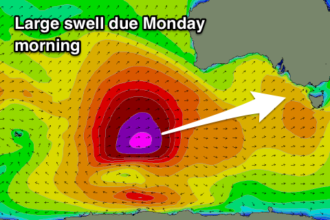
Mix of W/SW swells over the weekend, larger Monday morning
Victoria Forecast by Craig Brokensha (issued Friday 27th April)
Best Days: East of Melbourne Saturday morning, Surf Coast Monday morning, both coasts Tuesday and Wednesday mornings
Recap
Poor conditions yesterday with small to tiny amounts of swell through the morning, clean on the Surf Coast ahead of an onshore change and building windswell through the afternoon.
Today a stronger W/SW groundswell has filled in offering good 3-4ft sets on the Surf Coast and 6ft+ on the Mornington Peninsula but with moderate onshore winds.
Today’s Forecaster Notes are brought to you by Rip Curl
This weekend and next week (Apr 28 – May 4)
Today's W/SW groundswell will ease back through tomorrow, and winds are looking best for the beaches, with a light E tending E/NE breeze favouring spots east of Melbourne.
The Surf Coast reefs don't look too ideal with bumpy/lumpy easing surf from 3ft+, better on the beaches, while the Mornington Peninsula should ease from 4-5ft+.
Into Sunday an initial pulse of W/SW groundswell is expected ahead of a better W/SW groundswell late in the day, peaking Monday.
These two swells have been generated by the same storm, with an initial mid-latitude fetch of W/SW gales generating Sunday morning's swell, coming in around 2-3ft on the Surf Coast and 4-5ft+ on the Mornington Peninsula.
 The larger W/SW groundswell for late in the day and more so Monday morning was produced by a better polar fetch of slow moving severe-gale to storm-force winds south-west of WA.
The low producing this fetch is projecting slightly east-northeast through our western swell window while weakening today, dipping south-east tomorrow.
A long-period W/SW groundswell should peak Monday morning across our region, providing solid 4-6ft sets across swell magnets on the Surf Coast with 8ft sets on the Mornington Peninsula.
The swell is expected to ease through the afternoon, down further Tuesday from 3-4ft on the Surf Coast and 5-6ft on the Mornington Peninsula.
Coming back to the winds, and Sunday looks poor with a moderate to fresh S/SE tending S/SW breeze, while Monday looks best on the Surf Coast with a morning W/NW breeze, swinging SW through the day.
Tuesday is the day for the more open beaches with a morning N/NE offshore, possibly tending variable with only weak sea breezes expected. N'ly winds will continue to favour more exposed spots Wednesday as the swell continues to ease.
Besides a small mid-period W/SW swell for Thursday morning, we should see some new swell activity into Friday/Saturday, through the models are divergent on the mid-latitude storms pushing in from WA next week. Therefore check back here Monday for the latest on this. Have a great weekend!


Comments
Nice lines at Lorne this arvo.

Decent sized sets across the Bellarine this morning.

Can’t wait 4 the Swellnet Forecast for the Founders Cup. 5 days out you’d think the Boys would have it sorted. Oh and how about some feedback on the FB experiment? Did Swellnet’ server suffer overload?
Can’t wait 4 the Swellnet Forecast for the Founders Cup. 5 days out you’d think the Boys would have it sorted. Oh and how about some feedback on the FB experiment? Did Swellnet’ server suffer overload?