Pumping Tuesday and great from late week
Victoria Forecast by Craig Brokensha (issued Monday 26th March)
Best Days: Surf Coast Tuesday, east of Melbourne Wednesday morning, Surf Coast Friday, Saturday and Sunday morning
Recap
Small easing surf on the weekend and local thunderstorms threw a spanner in the works Saturday morning with onshore winds developing.
Conditions did improve late morning again across selected spots as winds tended back offshore but with the small swell, it wasn't too inspiring.
Sunday saw tiny clean conditions on the Surf Coast with a building windswell into the afternoon under strengthening W'ly winds.
The mid-latitude low linked to these strong W'ly winds ended up sitting a little further south and more in our swell window, hence resulting in larger developing surf today. We've got building clean surf from the 4ft range on the Surf Coast reefs, larger and stormy elsewhere and we should see the surf pushing above 6ft west of Melbourne but with strong W/SW winds.
Today’s Forecaster Notes are brought to you by Rip Curl
This week and weekend (Mar 27 – Apr 1)
This afternoon's large increase in W/SW tending SW swell will drop quickly through tomorrow as the mid-latitude low pushes off to the east and a high slides in quickly from the west.
We'll see excellent conditions across the Surf Coast with N/NW winds holding until early-mid-afternoon with weak sea breezes likely after, keeping conditions good most of the day.
The Surf Coast should ease from 4-5ft early, with 6ft to possibly 8ft sets on the Mornington Peninsula, dropping steadily through the day.
Come Wednesday the surf will be much smaller with fading 2ft sets on the Surf Coast and 3-4ft waves on the Mornington Peninsula with better N/NE winds for swell magnets, shifting more N/NW on the Surf Coast ahead of a late W/SW change.
This change will be linked to the first of a series of frontal systems pushing through our swell window over the coming period.
We'll see back to back mid-latitude and polar frontal activity through this week and weekend owing to a strong node of the Long Wave Trough pushing in across the Bight and then over to us by the weekend.
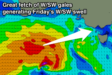
 Currently the first polar frontal system is east of Heard Island, generating a good fetch of W/SW gales.
We'll see this system broaden while pushing up closer to the country into this evening, followed by a secondary mid-latitude front 'piggy backing' on top of this front under WA. An additional fetch of broad W/SW gales will be projected through our western swell window, south of the Bight, slowly weakening as the front stalls slightly west of us Wednesday.
This should produce a moderate to large sized W/SW groundswell for Friday, with a late increase Thursday to 2ft to occasionally 3ft at magnets on the Surf Coast and 3-5ft on the Mornington Peninsula under W/NW tending W/SW winds.
Come Friday we should see much better 4-5ft sets across Surf Coast swell magnets with 6-8ft waves on the Mornington Peninsula with great NW tending W/NW winds and then W/SW into the afternoon.
The slow moving nature of the frontal progression through Wednesday and Thursday will help generate good amounts of reinforcing SW swell for Saturday with the Surf Coast at this stage looking to persist at 4ft, with 6ft+ waves to the east.
Winds look favourable as well with a light morning W/NW offshore before S/SE sea breezes kick in.
Looking at Sunday and beyond, the surf should continue to ease with a morning W/NW breeze across the Surf Coast, while some weaker mid-latitude fronts look to generate fun pulses of swell for early next week. More on this Wednesday.


Comments
the reefs this morning were not 4ft they were about 6ft on the sets and very consistent
Great to hear! I had 4-5ft but all reports came in at 3-4ft.