Very poor outlook
Victoria Forecast by Craig Brokensha (issued Friday 1st December)
Best Days: No good days
Recap
Super fun waves at swell magnets tomorrow, easing back from 2-3ft on the Mornington Peninsula, while the Surf Coast was small to tiny, best at 13th Beach with fading 1-2ft sets.
This morning the swell has bottomed out and conditions are clean, but an onshore change is on the way, bringing heavy rain ahead of it.
Today’s Forecaster Notes are brought to you by Rip Curl
This weekend and next week (Dec 2 - 8)
Looking at the weekend's outlook and there only change from Wednesday is a poorer wind outlook.
A surface trough that's responsible for the current weather is moving in slowly from the west, with it due to move across us early afternoon.
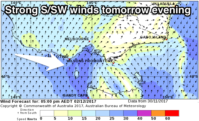
Over the weekend the trough will stall and strengthen, with strong S/SW winds due through tomorrow, and S/SW tending S/SE Sunday.
 Moderate amounts of S/SW windswell should build tomorrow afternoon across both regions, peaking through Sunday and then starting to ease Monday as the trough weakens.
It's hard to put a number on the size, but the Surf Coast isn't likely to get above 3-4ft later tomorrow and early Sunday, and the Mornington Peninsula 4-6ft.
Unfortunately winds will linger from the S/SE into Monday as the windswell eases, with poor E/SE winds Tuesday.
This will spoil a small new SW groundswell, though there's no major size to this swell in any case.
A relatively weak low that's currently south of WA is generating a good pre-frontal fetch of NW gales, followed by weaker post-frontal W/SW winds.
A small SW groundswell is due to fill in Monday, peaking through the afternoon to 2ft+ on the Surf Coast and 3-4ft+ in the Mornington Peninsula, easing Tuesday from 2ft and 3-4ft respectively.
Unfortunately there doesn't look to be an end to the onshore winds and poor swell, with another surface trough forming off the East Coast likely to form into a low and drift south-west towards us mid-week.
A front approaching from the west should then clear this system to the east, but also bring onshore SW winds.
Beyond this some better frontal activity may be seen, but in the meantime you'll have to hang in there. Have a great weekend!


Comments
Hey Craig, notice that little insta-spike on the Cape Sorell Buoy 11am Fri, from 0.8m significant to 2.8 in an hour - max from 1.2 to 5 in same time - where is that coming from?
The period is the dead giveaway, 6-8s.
This is from the trough moving east and going bang, with strong to gale-force S/SE winds.
You can also see this on the Cape Sorell wind observations.
Thanks Craig - *wonders if some of it is refracting inside the bay at Sandy Cape at present*
Edit: actually this is a really good lesson when sitting at home in Vic and seeing Sorell spike, don't always assume it's long period SW groundswell headed your way.
Yeah totally.