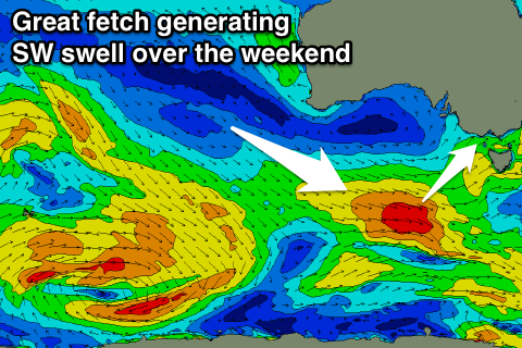
Lots of swell over the coming days, but onshore most spots
Victoria Forecast by Craig Brokensha (issued Friday 20th October)
Best Days: Both coasts Sunday and Monday mornings, Tuesday morning Surf Coast, Wednesday morning Surf Coast, Thursday both coasts
Recap
No surf yesterday with just a tiny line of swell showing every now and then across the coast.
Today onshore winds and a weak building windswell have created poor conditions across all locations, but we should see some stronger W/SW groundswell building later this afternoon, reaching 3ft+ by dark on the Surf Coast and 6ft on the Mornington Peninsula. Cape Sorell as seen below has jumped nicely, but periods are still relatively low.

This weekend and next week (Oct 21 - 27)
We're currently seeing a mix of building W/SW windswell from the remnants of a strong mid-latitude front that's generated a stronger increase in W/SW groundswell later today.
This front has brought today's onshore winds and we should see the Surf Coast reaching 3ft+ later today with 6ft sets on the Mornington Peninsula.
This swell should hold a similar size into tomorrow morning, while a reinforcing SW swell is due later in the day to a similar size as the morning, holding 3ft into Sunday with 4-6ft sets on the Mornington Peninsula.
Weaker trailing fetches of pre-frontal W/NW winds through our swell window this evening and tomorrow should keep weaker mid-period swell around 3ft on the sets early Monday at swell magnets on the Surf Coast and 4-5ft on the Mornington Peninsula, easing back through the day.
 Now looking at the expected conditions and onshore SW winds are due across most locations all weekend, but the Torquay region should see a few hours of more favourable W/NW breezes each morning.
Monday will play out similar though with weaker SW breezes across other locations.
We're looking at smaller leftover surf into Tuesday back to 2ft or so on the Surf Coast and 3-4ft on the Mornington Peninsula with a variable tending locally offshore breeze before sea breezes kick in.
Into Wednesday a small fun SW groundswell is due, generated by a small intense polar forming south-west of WA today, generating a slow moving fetch of W'ly gales.
This should provide infrequent 2-3ft sets on the Surf Coast and 4-5ft waves on the Mornington Peninsula, though winds are a little unsure with a a surface trough moving in from the west. We'll look at this closer Monday.
Longer term there's nothing significant until possibly late next weekend, but more on this Monday. Have a great weekend!

