Good clean weekend, mixed surf next week
Victoria Forecast by Craig Brokensha (issued Friday 30th June)
Best Days: Both coasts Saturday, beaches Sunday, both coasts Monday, Surf Coast Tuesday and Thursday
Recap
Great conditions again across the Surf Coast yesterday with a new inconsistent SW groundswell in the 3-5ft range with offshore winds most of the day, while the Mornington Peninsula was poor.
Yesterday afternoon's onshore change is persisting across most locations this morning with an increase in mid-period SW swell, while the Torquay region offered a period of early W'ly winds for desperate surfers.
This weekend and next week (Jul 1 - 7)
The front responsible for today's swell and winds is moving off to the east and with this we'll see the pressure gradient relax across the state this afternoon. Winds should become more variable, but into tomorrow we'll see offshore winds from the north with easing levels of mid-period SW swell.
Local N/NW offshores are due on the Surf Coast with easing 3-4ft sets, and local N/NE offshores to the east with easing 5-6ft sets.
Sunday will be a good day for the beaches with a fresher N'ly tending N/NE breeze and smaller surf. A new W/SW groundswell from pre-frontal NW winds isn't looking as favourable for the Surf Coast anymore, with inconsistent 2ft+ waves likely at magnets.
The Mornington Peninsula should see 4ft waves, with a possible slight kick into the afternoon.
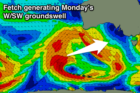
 Monday's W/SW groundswell is looking a little smaller than forecast on Wednesday.
The strong polar frontal progression generating the swell is currently projecting towards WA, but its strength and its projection isn't ideal for us.
We should still see a good inconsistent W/SW groundswell generated, building through Monday and reaching an inconsistent 3ft+ at swell magnets on the Surf Coast with 4-6ft sets to the east.
A gusty N'ly breeze will favour more exposed breaks across the state, tending W/NW into Tuesday as the swell eases and the remnants of the progression in the form of a mid-latitude low move in across us.
This low won't have any strength by the time it crosses us, with a weak W/SW windswell due Wednesday mixed in with a very inconsistent long-range SW groundswell through the afternoon.
The long-range groundswell isn't due to offer much size, with it currently being generated by a strong polar low in the Heard Island region. This low will lose its strength as it nears us with a very infrequent 3ft wave likely into Wednesday evening and Thursday morning on the Surf Coast, 5-6ft to the east.
Persistent W-NW winds will favour the Surf Coast during this period, with more N'ly breezes likely later Thursday and possibly Friday morning.
Longer term we should see a couple of stronger polar frontal systems pushing towards us under the country late week and into next weekend. This should produce some better W/SW swell, but more on this Monday. Have a great weekend!

