Good times keep on coming for the Surf Coast
Victoria Forecast by Craig Brokensha (issued Wednesday 14th June)
Best Days: Both coasts Thursday and Friday morning, Surf Coast Saturday onwards
Recap
Fun clean surf around 2-3ft on the Surf Coast all yesterday, while bumpy waves on the Mornington Peninsula improved into the afternoon as winds tended variable.
This morning the swell has eased just a touch but there are still 2-3ft sets breaking at magnets on the Surf Coast and inconsistent 3-4ft waves on the Mornington Peninsula with light offshore winds.
This week and weekend (June 15 – 18)
There's been no change to the inconsistent W/SW groundswell due across the coast tomorrow, mixed in with some mid-period energy in the mix as well.
The long-period forerunners have just hit the Cape du Couedic wave buoy in the form of 22.3s, but the bulk of the swell will be a fair way behind this and due tomorrow.
We should see the Surf Coast swell magnets coming in at an inconsistent 3-4ft with 5-6ft+ waves on the Mornington Peninsula. There may be the odd bigger bomb at times, but these will be far and few between.
The swell should ease off very slowly from Friday, back from 3-4ft at magnets on the Surf Coast and 5-6ft on the Mornington Peninsula, slowed into Saturday as a reinforcing W/SW swell moves in from a pre-frontal fetch of W/NW gales under WA today.
The Surf Coast should still see 3ft sets Saturday morning with 4-6ft waves on the Mornington Peninsula.
Conditions over the coming days are looking excellent for the Surf Coast with a moderate to fresh but easing NW breeze tomorrow, and then light NW tending variable winds both Friday and Saturday.
 The Mornington Peninsula may see a period of straighter N'ly winds tomorrow morning, variable into the afternoon, similar Friday morning.
Into Sunday we're now expected to see three separate swells filling in all at once, and while this sounds great, in the surf zone there's likely to be annoying double-ups with close spaced waves ruining each other.
The first swell will be from the W/SW, generated by a stronger fetch of pre-frontal W/NW winds moving in under WA and south of the Bight tomorrow. This should generate a pulse in size for Sunday morning, likely to 3ft+ on the Surf Coast and 5-6ft on the Mornington Peninsula.
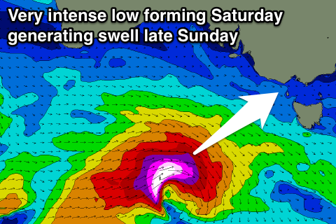
Trailing this W/NW fetch will be a polar fetch of gale to severe-gale W'ly winds, producing a stronger SW groundswell for the afternoon, likely to 3-5ft, but even more significant is a very strong mid-latitude low that's forecast to form south of the Bight Friday evening.
This low will deepen significantly in our south-western swell window, producing a burst of storm-force W/SW winds in our swell window Saturday, generating a large SW groundswell also for Sunday afternoon.
We're likely to see wave heights kicking strongly mid-afternoon reaching at this stage 5ft+ on the Surf Coast and 8ft on the Mornington Peninsula. Winds look great as well with a NW tending variable wind, but we'll have to have a closer look at this low on Friday.
Conditions look to remain favourably into early next week as the swells ease off, but more on this Friday.


Comments
22.2s forerunners have hit the Point Nepean buoy but no sign at Cape Sorell with the buoy not being as sensitive to the small long-period energy.