Fun surf at swell magnets Sunday morning, again Wednesday morning
Victoria Forecast by Craig Brokensha (issued Wednesday 28th December)
Sign up to Swellnet’s newsletter and receive the Victorian Forecaster Notes and latest news sent directly to your inbox. Upon signup you'll also enter the draw to win a surf trip to P-Pass for you and a mate. It doesn’t get much easier so click HERE to sign up now.
Best Days: Sunday morning Surf Coast swell magnets for a small wave and east of Melbourne, east of Melbourne Wednesday morning
Recap
Tiny waves across most of the coast yesterday, with the Mornington Peninsula and Phillip Island offering a few bigger surfable sets.
This morning the swell has totally bottomed out with near flat conditions on the Surf Coast and tiny waves on the Mornington Peninsula. A very inconsistent and small increase in W'ly swell is due this afternoon, but only to 2-3ft max on the Mornington Peninsula along with sea breezes.
This weekend (Dec 31 – Jan 1)
Don't bother too much about tomorrow. This afternoon's very small and inconsistent W'ly swell is due to ease and a W/NW wind will create bumpy/lumpy conditions on the Mornington Peninsula. The Surf Coast is due to be tiny.
Sunday is looking better across all locations with the arrival of a slightly stronger long-range W/SW groundswell under variable winds.
This swell has been generated earlier this week in the southern Indian Ocean, far far away from our coast.
Due to this there'll be very long waits between sets, but we should see the Surf Coast building to 2ft+ at magnets like 13th Beach and Fairhaven through the afternoon, and 3-4ft+ on the Mornington Peninsula.
The early morning will be smaller, but winds should be favourable for both coasts with a variable tending locally offshore breeze, ahead of a freshening W/SW to SW change late morning/midday.
This change looks to move through before the swell reaches its peak.
Next week onwards (Dec 2 onwards)
Sunday's change is now due to be weaker than forecast on Wednesday, and while only a small windswell was expected Monday, this will now be even smaller and weaker.
 The W/SW groundswell will be stronger, but easing from an infrequent 2ft at magnets on the Surf Coast and 3-4ft on the Mornington Peninsula but with a fresh S/SW breeze.
Tuesday doesn't look any better with small to tiny surf and S/SE winds.
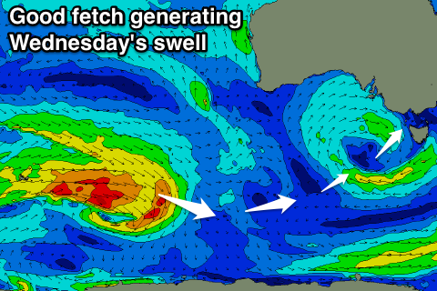
An inconsistent new SW groundswell is due Wednesday, produced by a pre-frontal fetch of strong to gale-force W/NW winds south-west of WA over the coming 24-48 hours. The low linked to this fetch will weaken while getting a touch closer, generating a fun swell for the beaches Wednesday morning.
The swell is expected to show later Tuesday but peak Wednesday morning around 2ft to possibly 3ft at swell magnets on the Surf Coast and 4-5ft on the Mornington Peninsula.
An E/NE breeze will favour the Mornington Peninsula, while afternoon E/SE winds will see a building SE windswell across the Surf Coast.
Longer term a new S/SW groundswell is on the cards late week with light winds, but more on this Monday. Have a great weekend and Happy New Year!

