Forget the weekend, fun waves early next week
Victoria Forecast by Craig Brokensha (issued Friday 21st October)
Best Days: Both coasts Monday morning and Tuesday, Wednesday morning Surf Coast
Recap
Pumping waves on the exposed beaches across the state yesterday with fresh and gusty offshore winds and easing 3-4ft sets on the Surf Coast with 5-6ft waves on the Mornington Peninsula.
Today the surf was much smaller and back to 2ft on the Surf Coast and 3-4ft to the east with early N'ly winds that have since shifted W'ly.
This weekend and next week (Oct 22 - 28)
The coming weekend isn't looking good at all.
Fresh and gusty onshore SW tending S/SW winds are due tomorrow and this will spoil a mix of new building W/SW and SW swells (along with a weak S/SW windswell). The Torquay region may see an early W'ly but with full and average 2-3ft sets, it's not worth driving down for.
Sunday will see poor onshore S/SW winds continuing along with easing levels of swell across both coasts.
Size wise the Surf Coast should see 3ft+ sets into tomorrow afternoon and Sunday morning with 4-6ft waves on the Mornington Peninsula.
The swell will be much smaller Monday morning but clean with leftover 2ft sets on the Surf Coast and 3-4ft waves on the Mornington Peninsula.
A light variable wind is due across both coasts, tending light N/NW on the Surf Coast, but to the east conditions will be clean enough for a paddle before sea breezes kick in.
Our new SW groundswell for Monday afternoon has been delayed a little, with it arriving mid-late afternoon when the sea breeze is in.
This swell, produced by a pre-frontal fetch of W/NW gales moving in from the south-east Indian Ocean, should build to a good 3ft on the sets late in the day on the Surf Coast, and 4-6ft on the Mornington Peninsula, easing from a similar size Tuesday morning under N/NW winds (N'ly east of Melbourne early).
 The larger and stronger groundswell due into the end of the week is still on track, but the winds are looking poor.
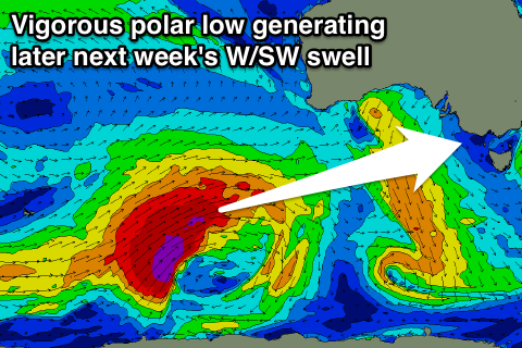
A vigorous polar low is expected to form in the Heard Island region this weekend, projecting a fetch of severe-gale to storm-force W/SW winds up more through our western swell window, rather than south-west.
With this we'll see a moderate to large W/SW groundswell being generated, building Thursday, peaking overnight and easing Friday.
The Surf Coast should build to a strong 4-5ft later Thursday with 6-8ft sets on the Mornington Peninsula, but this will be as a gusty onshore S/SE change moves through linked to a developing low off the NSW coast. Friday will also be poor with lingering S/SE winds, but we'll have another look at this Monday. Have a great weekend!

