Average couple of days, pumping from Thursday
Victoria Forecast by Craig Brokensha (issued Monday 11th July)
Best Days: Keen surfers tomorrow late on Surf Coast and early Wednesday, Thursday through the weekend Surf Coast
Recap
Fun clean easing 2-3ft waves on the Surf Coast Saturday with less than ideal but workable 4ft+ sets to the east.
Sunday was smaller again with fading 1-2ft sets on the Surf Coast, best on the beaches and easing 3ft sets on the Mornington Peninsula.
Today the surf has bottomed out as expected with tiny clean waves across most of the state, maxing at 1-2ft on the Mornington Peninsula. There's no real size due today, so don't plan on surfing.
This week (Jul 12 - 15)
Tomorrow is probably not worth penciling in as a surf day with tricky, small and acute levels of W'ly swell from a very strong mid-latitude that's hammering South Oz, in the Bight. Later in the day is the only chance of more swell but it's probably not worth driving far for.
This is directing a fetch of gale to severe-gale W/NW winds across us today, which isn't good at all for swell production.
Strong to gale-force N/NW tending NW winds will create tricky conditions tomorrow, with possible 2ft sets likely at 13th Beach on the Surf Coast and 3ft waves on the Mornington Peninsula.
Later in the day a better aligned fetch of W/SW winds will move through our swell window, kicking up more size probably to 3ft at swell magnets on the Surf Coast and 5-6ft on the Mornington Peninsula.
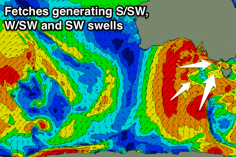
 Of greater importance is the large swell due into Wednesday, with various different pulses of W/SW, SW and S/SW groundswell due across the state.
Firstly the smallest S/SW swell will be generated by a fetch of gale to severe-gale S/SW winds wrapping around the bottom of the strong cold outbreak this afternoon through early tomorrow.
The W/SW tending SW energy will be produced as the front proper moves through Wednesday morning, with a broad and elongated fetch of SW gales being produced through our swell window.
With the timing off this front, the swell will be biggest into the afternoon, with a raw mix of windswell and groundswell through the morning. Our models are struggling to resolve these swells and over-forecasting the combinded size.
Size wise it's quite tricky but we should see 4-5ft waves on the Surf Coast early Wednesday, 8ft on the Mornington Peninsula, building to 6ft+ and 10ft respectively into the afternoon.
With fresh to strong W/NW winds, swinging W/SW mid-morning, it won't be the best surf day across the state.
Into Wednesday afternoon a stronger fetch of gale to severe-gale W/SW winds generated south-west of Tassie will generate a good secondary pulse of SW groundswell for Thursday morning.
This should keep the Surf Coast kicking around 5-6ft+ during them morning, easing into the afternoon with 8ft+ waves on the Mornington Peninsula. This will be the day to surf with weaker offshore W/NW winds persisting most of the day.
The easing trend will be slowed through Friday as a great fetch of W/SW gales continue to be generated through our south-western swell window Thursday.
Clean conditions with a NW breeze and easing 4-5ft waves are expected on the Surf Coast and 6-8ft sets on the Mornington Peninsula.
The weekend will continue to offer moderate amounts of swell with persistent offshores from the NW Saturday and N/NW Sunday. This will be from broad and strong pre-frontal W/NW fetches towards WA, but more on this Wednesday.

