Moderate surf with developing onshores
Victoria Forecast by Craig Brokensha (issued Monday 4th July)
Best Days: Both coasts tomorrow morning, possibly Thursday morning, east of Melbourne all weekend
Recap
Excellent conditions across the Surf Coast all weekend with a good reinforcing W/SW groundswell Saturday and offshore W/NW winds, while Sunday saw the swell start to drop away through the day under NW breezes. Options were limited to the east of Melbourne with Phillip Island performing the best.
This morning a new short-range swell was showing ahead of a longer-range and inconsistent W/SW groundswell with clean 2-3ft sets on the Surf Coast and 5-6ft on the Mornington Peninsula under local offshore winds. The long-range energy should build to 3-4ft and 6ft+ respectively into the afternoon but with long waits between sets as winds tend more N/NE.
This week and weekend (Jul 5 - 10)
The long-range W/SW groundswell due across the state this afternoon will ease back through tomorrow from likely the 3ft+ range on the Surf Coast and 5-6ft on the Mornington Peninsula but the winds will be dicey.
An early variable breeze is expected across all regions, from the east-northeast if anything before a freshening SE'ly moves in through the day.
This will create poor conditions while kicking up a weak windswell through the evening and into Wednesday.
The groundswell will continue to ease and with moderate to fresh S/SE tending S/SW winds, there'll be no quality options Wednesday.
The weather system responsible for tomorrow's developing onshore change will be a deepening surface trough and low drifting in across us from the west before stalling off the southern NSW coast.
 This will direct persistent fresh SE winds across the state both Thursday and Friday (swinging more E/SE). There's an outside chance for a more variable breeze on Thursday morning and this will be with the arrival of a new S/SW groundswell.
The source of this groundswell will be an elongated fetch of severe-gale W/NW winds along the polar shelf over the coming days, producing a good but inconsistent 3ft wave on the Surf Coast and 4-6ft on the Mornington Peninsula.
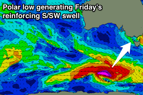
This swell is due to drop through Friday but a new reinforcing S/SW groundswell will arrive from a secondary polar low forming along the polar shelf mid-week.
This swell should be a touch more consistent and keep 3ft sets hitting the Surf Coast and 4-6ft waves on the Mornington Peninsula before easing off through the weekend.
Conditions will improve east of Melbourne Saturday as winds tend N/NE, with fun easing 3-5ft sets at swell magnets and peaky 2ft+ waves on the Surf Coast.
Into Sunday an acute long-period W/SW groundswell is due, generated by an intense but unfavourably aligned, structured and south-east tracking low forming south of WA.
A slim fetch of severe-gale to storm-force W'ly tending W/NW winds will be generated Thursday through our swell window before the low breaks down Friday.
This swell will favour locations east of Melbourne over the Surf Coast with inconsistent 3-5ft sets, and 2ft+ waves to the west. A peak is due through the morning, easing into the afternoon under strengthening N/NE tending N/NW winds associated with a broad mid-latitude low moving in from the west.
Longer term a large SW groundswell is expected into Tuesday/Wednesday next week as the mid-latitude low combines with a strong polar outbreak next week, but more on this Wednesday.


Comments
Buoy's are still dropping ... still thinking that new swell is gonna come in ? Do you think it'll just hit over night instead of this arvo ?
Thanks for these notes, great stuff