Tricky swell pulses, cleanest to the west
Victoria Forecast by Craig Brokensha (issued Wednesday 22nd June)
Best Days: Surf Coast tomorrow, especially later, Surf Coast Friday morning, Saturday, both coasts Sunday, Surf Coast Monday and early Tuesday
Recap
The swell hung in a little better than expected across the state yesterday morning with good clean 3ft waves on the Surf Coast (3-4ft at 13th Beach) while there weren't any decent options on the Mornington Peninsula with the wind. Phillip Island was cleaner and better for a wave.
Today a new short-range and weak W/SW swell has kept the surf up around 3ft at exposed breaks on the Surf Coast under offshore winds, while the Mornington Peninsula is bigger but bumpy. The swell should kick a little further through the day as winds swing more north-west.
This week and weekend (Jun 23 - 26)
The strengthening front that's currently moving through Bass Strait, generating today's short-range W/SW swell will move off to the east and swing winds more west-northwest out of our swell window this afternoon.
This will see the swell drop overnight with smaller 2ft+ leftovers across the Surf Coast tomorrow morning and larger 3-5ft waves on the Mornington Peninsula.
Our mix of long-range SW groundswell and short-range W/SW swell for later tomorrow are still on track, with the polar front generating the long-range energy breaking down yesterday.
This swell should kick to 3ft+ later in the day on the Surf Coast and the 6ft range on the Mornington Peninsula, peaking Friday morning to 3-4ft+ and 6ft to possibly 8ft respectively.
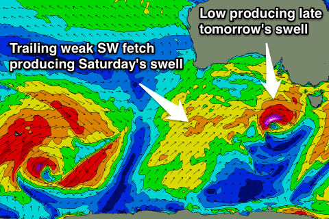
 The intense but tight mid-latitude low generating the W/SW swell is developing south of the Bight this morning, with a short-lived fetch of severe-gale W/SW winds forecast to be projected towards us as it dips east-southeast, passing under Tassie tomorrow.
The swell from this low is only expected to arrive near dark but should kick to a similar size as the SW groundswell, easing through Friday.
Conditions on Thursday are expected to be decent most of the day with a fresh to strong NW-N/NW breeze, tending W'ly mid-late afternoon. Friday will then see an dawn NW wind tending W/NW through the morning ahead of a gusty SW change through the day. The models are still divergent on the timing and strength of this change but it's more than likely after lunch.
Some new short-range swell is due from this change, but not over the pre-existing energy, and our models are over-forecasting the size with it incorrectly combining all three swells.
Saturday morning should see a new SW swell from a relatively weak but sustained fetch of strong SW winds projecting up slowly towards us over the coming days.
The Surf Coast is expected to offer good 3-4ft+ sets, easing through the day and then further from Sunday, slowed slightly be a smaller reinforcing W/SW swell. The Mornington Peninsula is due to 6ft to occasionally 8ft sets, dropping back from 5-6ft Sunday.
Winds on Saturday are looking OK with a morning W/NW'ly due to persist into the afternoon as an approaching front stops it from veering more SW. Sunday then looks good across both coasts with a N/NW'ly on the Surf Coast (tending more N'ly at times to the east).
Next week onwards (Jun 27 onwards)
Monday afternoon's large W/SW groundswell is still on track, but the timing has been pushed back a touch, with it really pulsing mid-late afternoon as winds go onshore.
Currently a vigorous polar low is forming in the Heard Island region, and we'll see this low project a slow moving fetch of severe-gale to storm-force SW winds in a captured fetch motion towards Western Australia. The low will then push through the Bight while weakening, continuing on and into us on Monday.
A large W/SW groundswell will result, arriving through Monday and kicking strongly later in the day, reaching 5-6ft across the Surf Coast and 8ft+ on the Mornington Peninsula but with a W/NW tending SW breeze.
A peak is due overnight, with the swell easing back through Tuesday under SW winds (W'ly early around Torquay). Hopefully this changes for the better over the coming days, but check back Friday for an update on this.


Comments
How long does it take for the swell to hit the Surfcoast from Cape Sorrell ? Does period and/or amplitude (wave height) affect this?
Cheers
Also is there any way to determine the swell direction from the Buoy readings ?
This has all been covered in a previous thread.. can't quite remember where but.
Found it.. https://www.swellnet.com/reports/forecaster-notes/victoria/2016/02/15/good-swell-onshore-tomorrow-cleaner-wednesday-morning
It takes one hr exactly , no need to study that old thread ,