Mixed week, best Friday morning
Victoria Forecast by Craig Brokensha (issued Monday 20th June)
Best Days: Surf Coast Tuesday morning, Wednesday, late Thursday, Friday morning, early Saturday, Sunday morning
Recap
Average conditions Saturday with a fresh onshore change and smaller surf through the morning, but a strong new SW groundswell filled in through the afternoon as winds eased late.
Sunday was much better but still lumpy with a light variable wind and solid easing 3-5ft waves on the Surf Coast with 6-8ft sets to the east.
This morning a gusty S/SE wind from the south-western flank of a strong low moving south off the East Coast has created poor conditions as the SW swell continued to ease.
This week (Jun 21 - 24)
The weekend's swell is expected to continue on its downwards trend through tomorrow but winds will improve as the low off the East Coast continues to track south. NW winds will wrap in around the back of the low creating clean conditions with easing 2ft+ waves on the Surf Coast and bumpy 3-5ft sets on the Mornington Peninsula.
From Tuesday we'll see a series of strong cold outbreaks impacting the state bringing much anticipated snow and also waves.
The first system moving through late tomorrow will be the weakest and smallest with a strengthening fetch of W/SW gales generated right on our doorstep, persisting into Wednesday morning.
This should produce building levels of short-range W/SW swell for Wednesday, building from 2-3ft early to 3ft+ at exposed breaks through the day on the Surf Coast (tiny in protected spots) and then building to 6ft on the Mornington Peninsula.
Winds will remain favourable for the Surf Coast all day Wednesday with a gusty W/NW breeze (NW at times likely through the morning).
We'll fall in between swells Thursday morning, but later in the day and more so Friday a mix of long-range SW groundswell and another short-range W/SW swell are due.
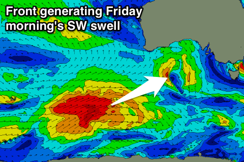
 Firstly the long-range energy will be generated by a vigorous polar front that developed just east of Heard Island over the weekend. This is producing a fetch of gale to severe-gale W'ly winds while tracking east but will weaken as it projects north-east towards us during this evening and tomorrow.
The swell from this system will be inconsistent but moderate in size, arriving later Thursday but peaking Friday morning to 3-4ft+ on the Surf Coast and 6ft to possibly 8ft on the Mornington Peninsula.
The short-range energy will be produced by a small and intense low spawning off the back of the weakening frontal system pushing towards us, with a fetch of pre-frontal severe-gale NW and then post-frontal W/SW winds being produced through our western swell window.
The mid-period swell from this low should kick later Thursday and ease Friday, reaching 3ft on the Surf Coast and 5-6ft on the Mornington Peninsula.
One more additional swell will be seen into Friday afternoon, with a strong but high riding front pushing in across the Bight due to move across us through the afternoon Friday. With this a fetch of W/SW gales will be generated through Bass Strait, producing an additional windswell, but not above the pre-existing swells.
Our models are however incorrectly combining theses swells and over-forecasting the size for Friday midday/afternoon.
Now Thursday should see fresh and gusty NW tending N/NW winds favouring the Surf Coast, with fresh to strong W/NW wind Friday morning ahead of the SW change kicking up the windswell.
This weekend onwards (Jun 25 onwards)
On the tail of the high riding front across us a better aligned fetch of strong SW winds will be aimed through our south-western swell window. A reinforcing SW groundswell is expected for Saturday morning, slowly easing from 3-4ft on the Surf Coast and 6ft+ on the Mornington Peninsula. Winds are due to be from the SW for the most part, W/NW early around Torquay.
 Sunday looks to be smaller again but with better NW winds.
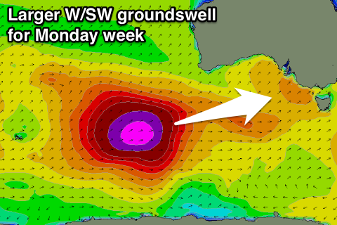
Now, as touched on last update, a very long-period and strong W/SW groundswell due for Monday week is still on track.
This will be generated by a vigorous polar low firing up around Heard Island Wednesday evening, projecting a slow moving fetch of severe-gale to possibly storm-force W/SW winds towards us right through the weekend.
We should see a moderate to large W/SW groundswell arriving through Monday and building to a very strong 5-6ft+ on the Surf Coast and 8-10ft on the Mornington Peninsula, but we'll run over this again Wednesday.

