Best Sunday morning, fun exposed breaks through early to mid-next week
Victoria Forecast by Craig Brokensha (issued Friday 22nd April)
Best Days: Keen surfers early Saturday Torquay, both coasts Sunday, Monday, Tuesday, east of Melbourne Wednesday
Recap
An inconsistent long-range SW groundswell provided infrequent but fun 2ft sets across the Surf Coast yesterday morning, with 3ft+ sets on the Mornington Peninsula under offshore winds. An onshore change moved through into the afternoon creating average conditions.
Today is a write-off with a fresh and gusty onshore wind and small junky windswell.
This weekend and next week (Apr 23 – 29)
Our mix of swells due into tomorrow are still on track, with a new SW groundswell due tomorrow morning ahead of a secondary slightly larger S/SW pulse into the afternoon.
The Surf Coast should see 3ft surf tomorrow morning, kicking a touch into the afternoon, with the Mornington Peninsula building towards the more consistent 6ft range.
Onshore S/SW winds are due across most locations, but the Torquay region is likely to see an early W'ly breeze, creating workable conditions for keen surfers.
Sunday is the better day to surf as the swells ease from 3ft+ on the Surf Coast and 5-6ft on the Mornington Peninsula along with a light variable wind (likely tending locally offshore) ahead of afternoon sea breezes.
The swell will become small into Monday but steady with a reinforcing W/SW swell keeping 2ft sets on the Surf Coast and 3-4ft+ waves on the Mornington Peninsula. Conditions will be great east of Melbourne with a N/NE tending variable wind (more N'ly at times to the west).
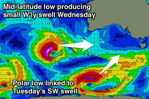
 Tuesday's possible swell from an intense mid-latitude low firing up south-west of WA and then drifting south-east through our swell window, doesn't look any good at all.
A very inconsistent W'ly pulse fro the initial stages of the low will be too west and small in nature, peaking Wednesday across our region to 1-2ft on the Surf Coast and 3ft+ on the Mornington Peninsula.
Before this though on Tuesday a fun pulse of SW groundswell from an intense but short-lived polar low is due, offering 2ft to occasionally 3ft sets on the Surf Coast through the morning, and 4-5ft waves on the Mornington Peninsula before easing into Wednesday.
Conditions will remain good but windy with a warm, fresh and gusty N'ly wind Tuesday and then slightly stronger N'ly breezes Wednesday.
Into the end of the week and weekend we've got some better looking polar frontal activity on the cards, generating some better groundswell into next weekend, but more on this Monday. Have a great weekend!


Comments
Hey Craig,
Me and a mate were going to go for a surf Tomoz down the surf coast he has golf in the morning so won't get there till 1 or 2 in the arvo was just going to surf a point break around the Torquay area. Will the winds still be light enough to not cause to much issues going into the arvo like will still be surfing till like 5pm
Cheers
Yeah it should still be workable, only probably moderate in strength, just keep your expectations in check.
Nah I wouldn't bother
Why does the Torquay region turn SW winds Westerly in the mornings ?
Cheers
The local topography of the Otway Ranges to the west steers the wind westerly if the synoptic setup is correct and the prevailing SW'ly not too strong to override it.