Fun swell Wednesday with light winds, possible stronger swell Sunday
Victoria Forecast by Craig Brokensha (issued Monday 8th February)
Best Days: Wednesday morning, Saturday morning, Sunday afternoon keen surfers on Surf Coast
Recap
Improving conditions across both coasts as the morning progressed Saturday as winds swung more offshore, with easing 2-3ft sets on the Surf Coast and around 4ft on the Mornington Peninsula.
The surf was smaller but clean again early yesterday before a slowly freshening onshore created deteriorating conditions.
This morning the surf was small and clean again with variable breezes, but a fresh onshore has since kicked up.
This week and weekend (Feb 9 - 14)
The surf is due to bottom out tomorrow morning and a moderate onshore wind at dawn will ease off mid-morning but you'd have to be desperate to head out.
Into the afternoon a new SW groundswell is due, followed by a secondary better pulse Wednesday, generated by a series of relatively weak polar fronts moving through our swell window over the weekend and into today.
A late kick to 2-3ft is due on the Surf Coast tomorrow, with 4-5ft sets on the Mornington Peninsula, peaking Wednesday to a better 3ft and 5-6ft respectively.
Conditions are looking better into Wednesday morning now as well with a more variable breeze due ahead of afternoon sea breezes.
A drop in size should be seen through Thursday from 2-3ft on the Surf Coast and 4-5ft on the Mornington Peninsula but winds are looking a little more dicey and light to moderate from the S'th, S/SE through Friday morning as the surf bottoms out again.
Through the day Friday another pulse of SW groundswell is due, from another relatively weak frontal progression pushing in from the Indian Ocean.
 A kick to an inconsistent 2-3ft and 4-5ft respectively is due Friday afternoon, easing back through Saturday. Both coasts are looking clean Saturday morning with morning offshores ahead of a SW change.
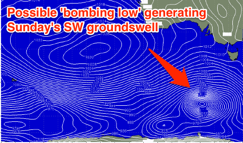
Into Sunday we've got a medium sized close-range SW swell on the cards as a relatively weak cold front moving in under the country deepens significantly to our south-west, 'bombing' (dropping over 24hPa in less than 24 hours) aiming a fetch of severe-gale to storm-force SW winds towards us.
This should produce a moderate sized SW swell for Sunday, peaking through the afternoon to 3-5ft on the Surf Coast and 6-8ft on the Mornington Peninsula, but with SW winds. More on this Wednesday though.


Comments
When a low 'bombs' does equal a big strong swell but only short lived?
Depends where it's located, how the low is orientated, where the strongest fetch is, and the actual forward track of the low as it bombs.
Some systems maintain strength after the initial bombing, and provide a long lived event whilst others can sometimes produce just a brief pulse of swell. And of course this has to coincide with favourable winds/tides etc too.
How much of an impact do tides have with incoming swell? E.g with a new swell coming in, would it be nullified by a major outgoing tide (say a low tide of .1 on the morn pen)? And vice versa?
As Ben said and in general it will be a stronger swell due to the larger swell periods associated with the stronger core winds.
This morning's update unfortunately doesn't have the low bombing any more. Bugger.
Craig
Are we still a chance for light local offshores tomorrow. doesn't feel like it....
Thanks
Sarge4, no (never expected local offshores) more variable winds from the SW if anything, so best on the Surf Coast.
Cheers Craig. I realized you guys weren't forecasting local offshores, I kind thought there might be though... Thanks as always for the reply.
Sweet.
How bout the sat morn offy? The forecast tools i use i.e swelly forecast, buoyweather, willyweather arent agreeing on that front. But i find forecaster notes to be consistently on the money more so ill roll with that ;)
Yep still looking like an early NW'er on the Surf Coast, more variable to the east.
Awesome. Just while i got your attention in regards to learning to read synoptics. Is there any books or sites you could direct me too pretty please :)